29 Fascinating English Channel Facts You Should Know About!


Gallery
The European continent's boundaries are predominantly maritime.
The continent is bound by the North Atlantic Ocean, Mediterranean Sea, Black Sea, and the Arctic Ocean. These water bodies are divided into smaller seas, straits, and gulfs because of the continent's various nooks, crannies, and bends.
The North Sea, The English channel & The Baltic Sea are the extended arms of the Atlantic Ocean. The Mediterranean Sea, separating the continents of Europe and Africa, has several elongated arms forming small seas along its length.
Some examples are the Adriatic Sea, Aegean Sea, Tyrrhenian Sea, and the Ionian Sea. The Barents Sea and the White Sea form a part of the Arctic Ocean boundary of Europe.
The sea of Azov in the Eastern part of Europe is sometimes regarded as the extension to the Black Sea. In this article, we will get to learn about a vital water passageway in European geography, the English Channel.
If this article has been a fun read so far, check out our other fantastic suggestions: the Red Sea and the Sea of Azov.
History Of The English Channel
The English Channel is an oceanic water body separating Northern French from Southern England. The Channel meets the Atlantic Ocean along an imaginary line drawn between the Scilly Isles and the Isle of Ushant.
The Isles of Scilly forms the most southern tip of England in the Atlantic Ocean, whereas Ushant Isle is a French island forming the Westernmost point of the nation on English Channel waters. The Channel merges into the North Sea at the Strait of Dover.
The English Channel is divided into English and French territorial waters at the Strait of Dover.
In the rest of the vast regions of the Channel, the territorial waters of the two nations are divided by international waters. While these are the current geographic conditions of the Channel, let us take a look at its history and how it was formed.
Before the last glacial period occurred, the British Isles were a part of Continental Europe connected by a ridge between Weald in England and Artois in France during the Pleistocene Epoch.
This connecting ridge restrained a glacial lake present in a region now submerged under the North Sea.
During the Devensian glaciation (the British name for the Last Glacial period) around 10,000 years, the whole of the North Sea and most parts of the British Isles were engulfed in ice sheets, and the sea level was sea level 390 ft (120 m) lower than it currently is.
The glacial lake, fed by meltwater from northern regions, massively flooded a few times over the centuries submerging the ridge connecting the British Isles and the European mainland.
These floods washed westwards into the Atlantic ocean, forming a depression.
Over the many centuries, after many sea-level changes, this depression formed into a channel. Through this channel, the Channel River passed, draining the combined waters of rivers Rhine and Thames westwards into the Atlantic Ocean.
The constant flow into these water bodies eventually eroded and excavated the channel even wider, giving way to the present-day English Channel.
Throughout its history, the English Channel acquired many names. This channel's first names were the Latin names of Oceanus Britannicus or Mare Britannicus, meaning the British Ocean or The British Sea by the Romans.
The first recorded use of the English Channel title was in the 15th century, which became the official name by the 19th century.
The French have called the English Channel 'La Manche' (the sleeve) since the start of the 17th century, referring to its sleeve-like appearance. A name was given to the English Channel and the North Sea collectively as the Narrow Sea.
Why The English Channel Is So Important
On the English Channel map, we see the nation of England on its North and France on its South. So, the channel connects two of the most influential countries of the present time.
In history, the channel had served as an important barrier against invasion for the kingdom of Britain. The English Channel witnessed many invasions and attempted attacks on Britain.
Some of the most important attempted invasions in history via the English Channel were the Napoleonic wars, the Spanish Armada, and the invasion by Nazi Germany during World War II.
The successful invasions were the Roman conquest, the Glorious Revolution, and the Normandy landings.
The channel also witnessed many Naval battles like the Battle of Portland, the Battle of Dover, the Battle of the Downs, and the Battle of the La Hougue. Though the English Channel was a barrier against the enemy, it was also a route for cultural exchange and trade through the seaway.
Even to this modern-day, the English Channel serves as one of the world's busiest and most important shipways. Nearly 500 ships sail through the English Channel each day.
This channel connects Continental Europe to the British Isles and Northern Europe to the rest of the world. The trade in this channel amounts to nearly 20% of the world's maritime trade.
And, for the trade, both global and cross-channel, many seaports and ferry docks have been constructed along the English Channel coast on both the English and French sides. A 35-minute train service running through the channel tunnel also helps with the transportation of people across the channel along with the ferries.
The beautiful views of the various port cities and coastal resorts along the channel coast in both nations have also contributed to tourism. For fun and leisure, short trips across the English Channel are called channel hopping.
Length And Width Of The English Channel
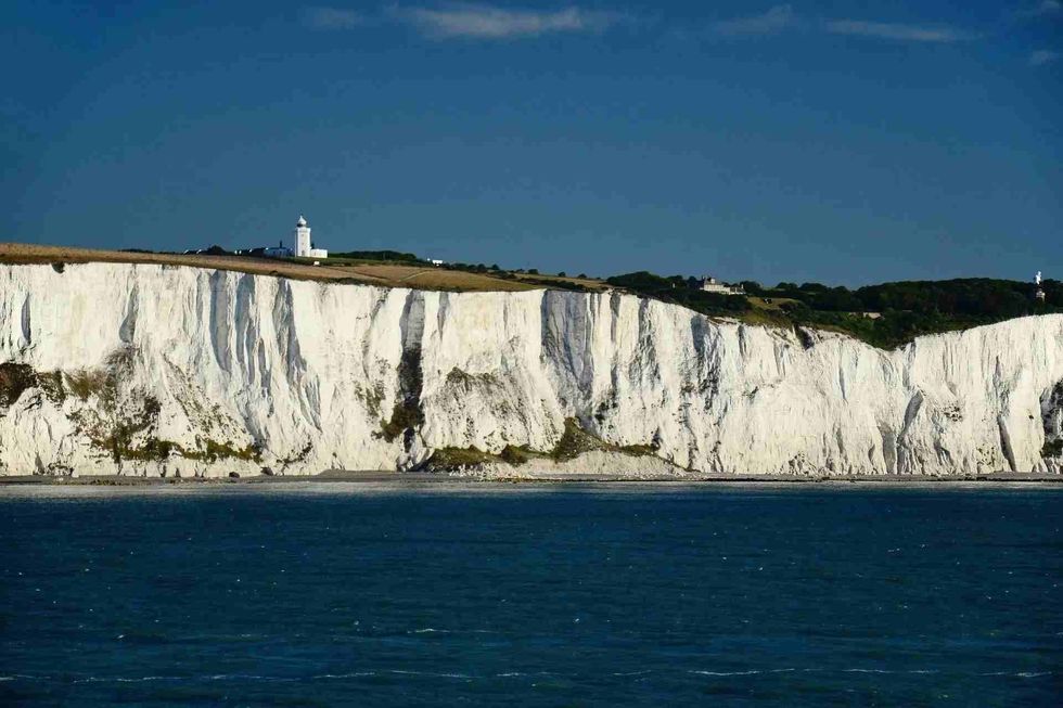
The coastline of the English Channel provides breathtaking views and sceneries. There are many coastal cities along the English coast and the French coast. Some of the most beautiful attractions are the White Cliffs of Dover, the city of Saint-Malo, and the various gorgeous Channel Islands.
The Channel Islands is the name given to the archipelago off the French coast. The Channel Islands are self-governing bodies that are also British crown dependencies.
They consist of four major islands of Jersey, Guernsey, Sark, and Alderney. The Channel Islands also include several other islets, both habited and inhabited. All this geography runs along the length and breadth of the English Channel.
The English Channel stretches from the Atlantic Ocean on the West to the North Sea on the East over 350 mi (563.2 km). However, the English Channel width is not a consistent measure over the English channel length.
The water body is the most narrow at the Strait of Dover, recording the minimum distance of 21 mi (34 km). At its widest, the English channel records a distance of 150 mi (241.4 km).
Calculating across the length and width of the channel, it measures an area of 29,000 sq mi (75,109.65 sq. km).

Swimming Across The English Channel
Over the centuries, because of its narrow and safe nature, many people have tried crossing the English Channel in various ways.
People have crossed the narrow sea via multiple boats and ships (both powered and non-powered), amphibious vehicles, and various new crossing technologies. The English Channel has been crossed via air and also through the English Channel Tunnel, a railway tunnel across the Strait of Dover built at a depth of 250 ft (76.2 m) from the sea bed.
In addition to these, many brave humans have crossed the English Channel waters by swimming across it.
The marathon swim across the channel occurs between Folkstone or Dover in England and Cap Gris Nez in France, along the narrowest part of the channel. Though the technical English Channel distance for swimming is 21 mi (34 km) straight, it changes based on the currents.
On August 25, 1875, Captain Matthew Webb became the first human to swim from England to France across the Strait of Dover.
Many people followed his lead over the next few decades.
The Channel Swimming Association was formed to ratify and authenticate the swims across the channels, which was later dissolved and founded as two bodies Channel Swimming and Piloting Federation (CSPF) and Channel Swimming Association (CSA), in 1999. Along with solo marathon swims across the channel, swimmers also take part in relay swims, two-way and three-way swims.
A grand total of 4133 swims, including all solo, relay, and special category swims, participated by more than 10,000 swimmers. The swimmers come from all age groups, from the youngest being an 11-year-old boy from England to the oldest being a 73-year-old man from South Africa.
The swim across the English Channel knows no gender bias as 37% of the total swimmers constitute females.
Various swimmers have set multiple records on the marathon swim across the channel. Still, the fastest channel crossing was recorded by an Australian swimmer named Trent Grimsey in 2012, with the record of completing the swim in six hours and 55 minutes.
Depth Of The English Channel
Our Earth is full of water bodies, ranging from massive oceans covering significant parts of the globe to small neighborhood ponds or lakes. The Oceans of the world can be as deep as they are wide. Within these depths, thousands of species of flora and fauna grow and live. The water is a vast habitat of its own accord.
The English Channel is a relatively shallow water body, its depth ranging from 150 ft (45.72 m) at the shallowest part at the Strait of Dover to 565 ft (172.2 m) in the Hurd Deep, the deepest point of the British Channel. The English Channel depth measures a recording of 400 ft (122 m) at its widest region.
Here at Kidadl, we have carefully created many interesting family-friendly facts for everyone to enjoy! If you liked our suggestions for 29 fascinating English Channel facts, you should know about them, then why not take a look at the Ionian Sea or the East China Sea?


We Want Your Photos!
More for You


See All
Bachelor of Science specializing in Botany, Master of Science specializing in Clinical Research and Regulatory Affairs
Sridevi ToletyBachelor of Science specializing in Botany, Master of Science specializing in Clinical Research and Regulatory Affairs
With a Master's degree in clinical research from Manipal University and a PG Diploma in journalism from Bharatiya Vidya Bhavan, Sridevi has cultivated her passion for writing across various domains. She has authored a wide range of articles, blogs, travelogues, creative content, and short stories that have been published in leading magazines, newspapers, and websites. Sridevi is fluent in four languages and enjoys spending her spare time with loved ones. Her hobbies include reading, traveling, cooking, painting, and listening to music.
Bachelor of Fine Arts specializing in International Business

Vikhaash SundararajBachelor of Fine Arts specializing in International Business
With a background in International Business Management, having completed his degree at the University of Hull. Vikhaash has volunteered with 'Teach For India' to help students create a monthly newsletter. In his free time, he enjoys sports and was the assistant captain of his school's hockey team. He has also gained marketing experience through an internship at Decathlon Sports India.
Disclaimer
1) Kidadl is independent and to make our service free to you the reader we are supported by advertising. We hope you love our recommendations for products and services! What we suggest is selected independently by the Kidadl team. If you purchase using the Buy Now button we may earn a small commission. This does not influence our choices. Prices are correct and items are available at the time the article was published but we cannot guarantee that on the time of reading. Please note that Kidadl is a participant in the Amazon Services LLC Associates Program, an affiliate advertising program designed to provide a means for sites to earn advertising fees by advertising and linking to Amazon. We also link to other websites, but are not responsible for their content.
2) At Kidadl, we strive to recommend the very best activities and events. We will always aim to give you accurate information at the date of publication - however, information does change, so it’s important you do your own research, double-check and make the decision that is right for your family. We recognise that not all activities and ideas are appropriate for all children and families or in all circumstances. Our recommended activities are based on age but these are a guide. We recommend that these ideas are used as inspiration, that ideas are undertaken with appropriate adult supervision, and that each adult uses their own discretion and knowledge of their children to consider the safety and suitability. Kidadl cannot accept liability for the execution of these ideas, and parental supervision is advised at all times, as safety is paramount. Anyone using the information provided by Kidadl does so at their own risk and we can not accept liability if things go wrong.
3) Because we are an educational resource, we have quotes and facts about a range of historical and modern figures. We do not endorse the actions of or rhetoric of all the people included in these collections, but we think they are important for growing minds to learn about under the guidance of parents or guardians.