15 Fraser River Facts: Find Out About This Mighty Canadian River!

Gallery
Do you know of any river in which fish swim along with gold?
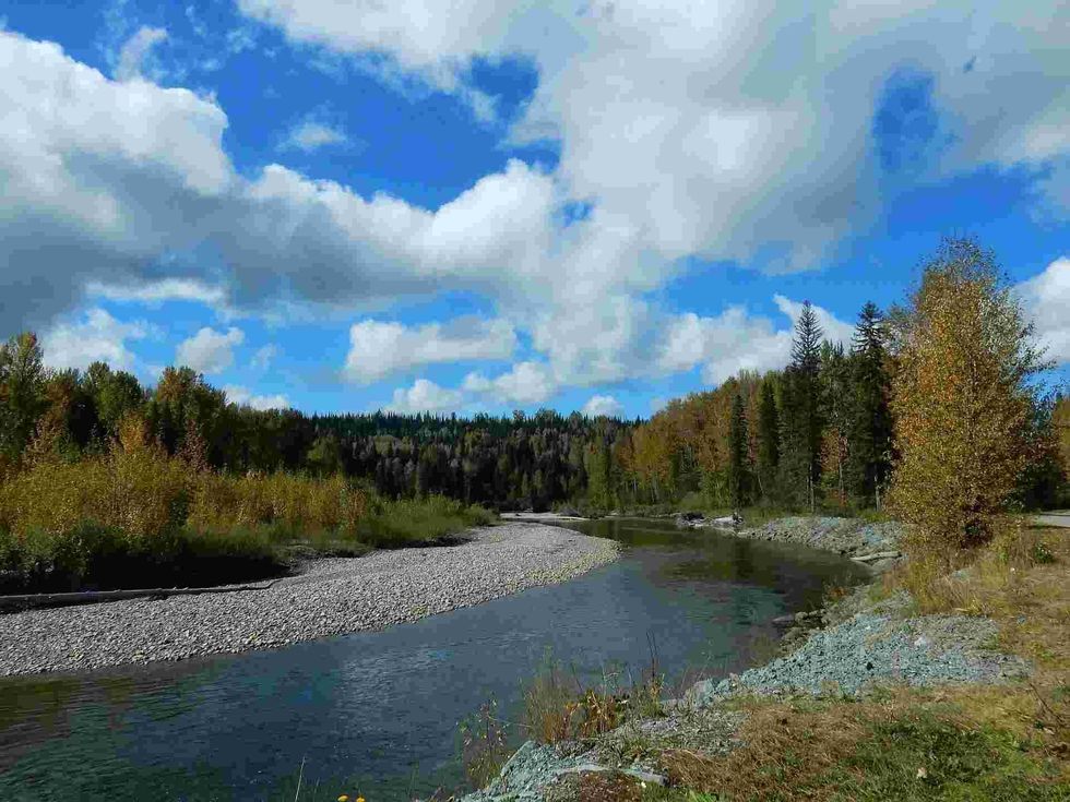
The Fraser River in Canada is one such majestic river.
Best known for having a unique variety of fish in its waters, like the white sturgeon, steelhead trout, and all five species of the Pacific salmon: chinook, coho, chum, pink, and sockeye salmon, the Fraser River also witnessed a gold rush in 1858 for the gold deposits found in its river system at that time.
The Fraser River is the 11th-longest river in Canada and the longest river running entirely in the province of British Columbia. It is more than 10,000 years old and is one of the most important rivers of Canada.
The river rises in Fraser Pass in the Rocky Mountains of Canada and flows into the Strait of Georgia, near Vancouver.
The Fraser River's journey from the Rockies in British Columbia to its mouth near the city of Vancouver is 854 mi (1,374 km) long. Most of the Fraser River’s drainage basin lies within British Columbia, but a small part of it lies in the United States of America, in Washington.
The river runs at a speed of 140,269 cu ft/s (3,972 cu m/s), and it discharges about 20 million tons of sediment into the ocean every year. The deepest part of the Fraser River at Abbotsford in British Columbia has shifted its position and deepened further recently.
Read this article further to know more amazing Fraser River facts and expand your knowledge on this mighty river and its tributaries.
Fun Facts About The Fraser River
Here are some fascinating facts about the Fraser River:
The Fraser River is more than 10,000 years old and was a vital source of livelihood for the indigenous people of Canada, who relied on the river for its resources, such as drinking water, fish for food, and using the river for transportation.
The Fraser River is named after Simon Fraser, a Scottish explorer who in 1808 became the first-ever European to travel the majority of the Fraser River’s length. There are about 2.9 million people currently living in Fraser Basin, which means that about two-thirds of British Columbians live in the Fraser River’s basin.
Nearly 300,000 people are living in the flood plains of the Lower Fraser River. The Fraser River’s water flow of 140,269 cu ft/s (3,972 cu m/s) can fill three swimming pools per second!
The flow of the river is highly dependent on the seasons: the river’s summer flow can be 10 times larger than the winter discharge. Based on its large natural and cultural heritage, the Fraser River was declared as a Canadian Heritage River in 1998.
Fort Langley was intentionally constructed on the south bank of the Fraser River that, in the event that Fort Vancouver was lost to the Americans, then Fort Langley would secure British claims to both sides of the Fraser River. Fort Langley is now a tourist attraction, with live re-enactments of gold panning.
Facts About The Fraser River's Ecosystem
The Fraser river’s ecosystem comprises a wide variety of flora and fauna, from a wide variety of fish to various types of vegetation. We look at some facts about the river's ecosystem:
The Fraser River has many famous fishing spots, and the popular fish in it include the white sturgeon, steelhead trout, and all five species of the Pacific salmon fish, as listed above.
The Lower Fraser River is a mixing place for the ocean’s saltwater and river’s freshwater and is where most fish spend their winter seasons to breed. The Fraser River basin supports a wide range of vegetation as it includes grassland, alpine tundra, coniferous forests, and coastal rainforest.
Major species of trees include the Douglas fir, Alpine fir, lodgepole pine, white spruce, western hemlock, and trembling aspen. Grasslands are found in arid regions near the river. Popular wildlife species in this region include black-tailed deer, bighorn sheep, grizzly bear, black bear, muskrat, wolf, and woodland caribou.

Lakes In The Fraser River
There are a number of lakes that drain into the Fraser River, most of them located in British Columbia, while others are near Vancouver. Here are some of the most important lakes in the Fraser River system:
Yellowhead Lake: Yellowhead Lake is the source of the Fraser River in the Rocky Mountains of British Columbia. The lake is strangely shaped and is approximately 3.5 mi (5.6 km) long. Interestingly, its width depends on where you’re standing and viewing it from.
Moose Lake: Moose Lake is the only lake that actually lies on the course of the Fraser River. It is a long lake with a medium width and is wider at its inlet of the Fraser River, and becomes thinner towards the outlet.
Quesnel Lake: Quesnel Lake is formed from glacial activities and is a major tributary of the River Fraser. It lies in British Columbia, is 1,677 ft (511 m) deep and is known as the deepest fjord lake in the world.
Seton Lake: Seton Lake is a long freshwater lake draining into the Fraser River, through the Seton River, at the town of Lillooet, and is 1,518 ft (462 m) deep.
Where The Fraser River Flows
The Fraser River has a drainage basin of 90,347 sq mi (234,000 sq km) and rises on the western slopes of the Rocky Mountains in Fraser Pass, British Columbia.
The River Fraser then flows along the flat valley floor of the Rocky Mountain Trench, meeting the Nechako River from the north-west at Prince George, British Columbia. It then moves southwards, cutting through the Fraser Plateau and forming the Fraser Canyon.
From here, the Fraser River moves towards Canada’s border with the United States while being joined on the way by numerous tributaries, such as the Chilcotin River near the city of Williams Lake, the Bridge River, and Seton River at Lillooet, and the Thompson River at Lytton.
When it is about 40 mi (64 km) away from the border, it runs through another canyon which has the Caste Ranges on its east and the Coast Mountains on its west. A famous portion of this canyon is called Hell’s Gate and is located in the town of Boston Bar.
As the canyon opens up at Yale, the river widens. The Fraser River turns west and runs in a south-west direction before bending in the north-western direction at Mission and Abbotsford.
From here, the Fraser River flows past Maple Ridge, Pitt Meadows, Port Coquitlam, and North Surrey. It then turns south-west again near New Westminster, where it splits into two arms: the North Arm, which forms the southern border of the city of Vancouver, and the South Arm, which separates the cities Richmond and Delta.
After traveling about 60 mi (96 km), both these arms of the Fraser form a delta, where there they descend into the Strait of Georgia near Vancouver.


We Want Your Photos!
More for You


See All
Master of Computer Science
Abhijeet ModiMaster of Computer Science
An experienced and innovative entrepreneur and creative writer, Abhijeet holds a Bachelor's and Master's degree in Computer Application from Birla Institute of Technology, Jaipur. He co-founded an e-commerce website while developing his skills in content writing, making him an expert in creating blog posts, website content, product descriptions, landing pages, and editing articles. Passionate about pushing his limits, Abhijeet brings both technical expertise and creative flair to his work.
Disclaimer
1) Kidadl is independent and to make our service free to you the reader we are supported by advertising. We hope you love our recommendations for products and services! What we suggest is selected independently by the Kidadl team. If you purchase using the Buy Now button we may earn a small commission. This does not influence our choices. Prices are correct and items are available at the time the article was published but we cannot guarantee that on the time of reading. Please note that Kidadl is a participant in the Amazon Services LLC Associates Program, an affiliate advertising program designed to provide a means for sites to earn advertising fees by advertising and linking to Amazon. We also link to other websites, but are not responsible for their content.
2) At Kidadl, we strive to recommend the very best activities and events. We will always aim to give you accurate information at the date of publication - however, information does change, so it’s important you do your own research, double-check and make the decision that is right for your family. We recognise that not all activities and ideas are appropriate for all children and families or in all circumstances. Our recommended activities are based on age but these are a guide. We recommend that these ideas are used as inspiration, that ideas are undertaken with appropriate adult supervision, and that each adult uses their own discretion and knowledge of their children to consider the safety and suitability. Kidadl cannot accept liability for the execution of these ideas, and parental supervision is advised at all times, as safety is paramount. Anyone using the information provided by Kidadl does so at their own risk and we can not accept liability if things go wrong.
3) Because we are an educational resource, we have quotes and facts about a range of historical and modern figures. We do not endorse the actions of or rhetoric of all the people included in these collections, but we think they are important for growing minds to learn about under the guidance of parents or guardians.