How do you feel when you see a dark, gloomy storm cloud enveloping the blue sky?
In many cultures, a storm cloud serves as a premonition of misfortune as most storm clouds bring destruction. However, it's only after the destruction that regeneration is possible.
In your childhood, you must have surely observed white fluffy layers that cause tiny drops of water to fall from the sky? Didn't it resemble soft cotton balls? Well, this is the most obvious introduction to clouds for juveniles. However, with knowledge, a deeper perspective of the clouds was available thanks to the brightly colored geography textbooks.
A cloud is a huge mass of ice crystals or tiny droplets of water that form in the atmosphere as a result of the condensation of water. Cloud formation takes place through the water cycle process.
They play a vital role in ensuring the sustenance of life on Earth.
Clouds are responsible for maintaining a balance in weather conditions by bringing in rains and storms. A shower of rain in summer helps in cooling down the weather, whereas it also entraps the sun's heat to maintain warmth during cold nights.
Clouds come in varying shapes and shades. Some display a snow-white color while others have shades of pink, but what are cumulonimbus clouds?
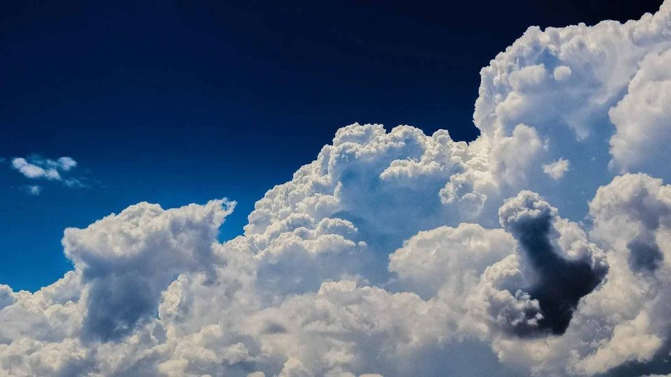
The word 'cumulonimbus' is the juxtaposition of the Latin terms 'cumulus' and 'nimbus' that translates to 'heap' and 'rainstorm'. Cumulonimbus clouds have a vertically towering structure formed due to convection.
They bring about severe weather conditions like thunderstorms and tornados, sometimes followed by severe rain, hail, and lightning. Despite being common in warmer climates of tropical regions, the winter clouds are the harbinger of destructive weather, often leading to blizzards, thunderstorms, and torrential snow.
If you have a fascination for geography, then be sure to check out these enthralling facts about the geosphere and facts about cirrus clouds.
Different Types Of Clouds
There are primarily three distinct types of clouds. Divisions have also been made concerning the level of formation. Let's take a look at the different types of clouds that influence the Earth's temperature.
High clouds refer to those clouds that occur at the height of around 16,000-43,000 ft (4876.8-13106.4 m). As the name suggests, these clouds reach the highest levels. Clouds such as the cirrostratus, cirrocumulus, and cirrus clouds are examples.
On the other hand, clouds that are created at the height of 7,000-23,000 ft (2133.6-7010.4 m) constitute the Middle clouds. The altocumulus and altostratus clouds are found in the middle layer.
Lastly, the Low clouds like stratocumulus and stratus float close to the ground surface at an altitude below 7,000 ft (2133.6 m). There are also vertical clouds like the cumulus and cumulonimbus clouds. Since a cumulonimbus cloud towers upwards, it can pervade all three layers as an anvil cloud develops on top of the main cloud.
Cirro-form: The term 'cirrus' has been derived from Latin meaning 'curl'. These whitish clouds comprising ice crystals have a significant hair-like appearance and are mostly associated with storms.
Strato-form: This term also has its roots in Latin, which implies 'layer'. These clouds stretch over a large area covering a vast expanse of the sky.
Cumulo-form: These clouds look like small tufts of cotton spread across the sky as they form in small detached clusters. While these clouds appear flatter at the base, they have an overall dense look.
Nimbo-form: This is a special cloud type that is the culmination of all the three variations of cirro, strato, and cumulo. It brings the rain.
Species Of Cumulonimbus Clouds
Do you know about the different species of cumulonimbus clouds? Let's see.
The towering cumulonimbus clouds have been classified into three separate species, namely cumulonimbus incus, cumulonimbus capillatus, and cumulonimbus calvus. These clouds possess distinct differences in appearances.
For instance, the top section of the cumulonimbus incus cloud is shaped like an anvil, while cloud tops of cumulonimbus capillatus are cirrus-like, offering it a curly, hair-like look. In contrast, the cumulonimbus calvus exhibits a cotton-like puffy top.
Cumulonimbus Cloud Supplementary Features
The cumulonimbus cloud posits eight supplementary features. Here's the list.
The eight features, namely incus, murus, mamma, arcus, virga, tuba, cauda, and preacipitatio, define the characteristics of the cumulonimbus cloud. Some features like murus, incus, and cauda are solely related to the cumulonimbus cloud.
Cumulonimbus arcus is the shelf cloud with a gust collar. In some clouds, there's a tuba, that is, the column that protrudes from the cumulonimbus cloud base.
The tuba can develop into a funnel cloud or tornado. While cumulonimbus murus is the wall cloud with lowering cloud, cumulonimbus cauda, the wall cloud, is fastened to the murus. Cumulonimbus mamma has a sac-like appearance.
Cumulonimbus Cloud Accessories & Other Clouds
Let's learn about the four accessories connected with the cumulonimbus cloud.
Cumulonimbus cloud accessories comprise pannus, flumen, velum, and pileus. Cumulonimbus flumen possesses a beavertail; pileus dons a cap on its cumuliform, while velum exhibits a veil that runs horizontally, and the pannus has rugged frazzles. Did you know that clouds, including cumulus clouds, can travel at a speed of 30-120 mph (48.28-193.12 kph)?
Similar Cloud Types
The top of the cumulonimbus cloud exhibits a flattened look that resembles an anvil dome. Generally, these clouds remain at a height below 20,000 ft (6,096 m), but they can stretch upwards. In fact, the vertical top of the clouds can extend more than 39,000 ft (11,887.2 m).
The lower section of the cumulonimbus cloud is composed of tiny water droplets, but the upper section is formed from ice crystals since the temperature is under zero degrees at that altitude. Once the cloud converts into a storm cell, it might last for some long hours.
These thunderstorms are accompanied by thunder, lightning, strong winds, hail, and even tornadoes. Heavy rains brought in by the cumulonimbus clouds are short-lived for about 20 minutes, although they can lead to flash floods.
There are certain cloud types similar to Cumulonimbus clouds. These clouds draw a resemblance with both the cumulus clouds and nimbostratus. The cumulonimbus cloud is the developed version of a cumulus cloud. Distinguishing between the cumulonimbus and nimbostratus is pretty challenging as both have precipitation. However, murus, arcus, and clauda help in identifying the former.
Here at Kidadl, we have carefully created lots of interesting family-friendly facts for everyone to enjoy! If you liked our suggestions for facts about cumulonimbus clouds then why not take a look at what do nimbus clouds look like, or what do pink clouds mean.