Rhode Island Major Rivers: Amazing Facts On Largest Inland Water Body


Gallery
Rhode Island is the tiniest of the 50 States in terms of area and is located in the New England region.
Just two other states have land borders alongside Rhode Island. Rhode Island is bordered on the south by the straits of Rhode Island Sound and Block Island Sound.
Between Long Island, NY and, Block Island, RI, it shares a brief maritime boundary with New York State. Narragansett Bay, an Atlantic Ocean entrance, stretches far into Rhode Island's southeast corner.
In allusion to the vast bays and inlets that make up over 14% of the state's total territory, Rhode Island has been dubbed the 'ocean state'. Five counties make up the state of Rhode Island with no real mountains.
In the 17th century, the Province of Rhode Island with Providence plantations was established. In the 1630s, English colonists arrived on what is now Aquidneck Island (Rhode Island).
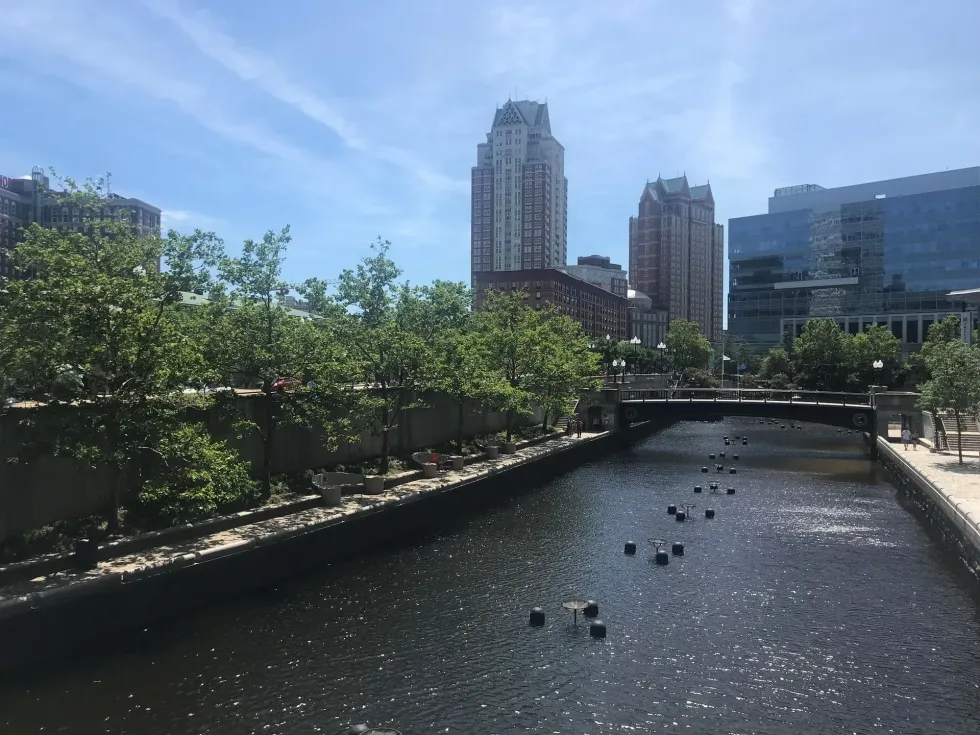
Providence, Rhode Island's capital, most significant, and the most populated city is situated in Providence County, on Narragansett Bay, just at the mouth of the Providence River. The 8 mi (12.8 km) long Providence River has been smoothed to facilitate interior traffic.
It appears in downtown Providence by Moshassuck and Woonasquatucket and runs 8 mi (12.8 km) into Narragansett Bay.
Rhode Island is situated in the northeastern (New England) region of the US, spanning only 1213.9 sq. mi (3,144 sq. km). Jerimoth Hill is Rhode Island's tallest peak.
Narragansett Bay, a northern continuation of the Atlantic Ocean, is Rhode Island's most unique characteristic. Block Island is notable for its windswept plains and rocky seaside bluffs. The Atlantic Ocean is the lowest point in the state.
The following article consists of the river systems in the state of Rhode Island. If you think you would like to learn more about all the fun things in the world, check out the Rhode Island state symbol and Rhode Island colony facts.
Rivers Of Rhode Island With Their Length
From the junction of Mill Brook and the Middle River at Worcester, Massachusetts, towards the Seekonk River of Pawtucket, Rhode Island, the Blackstone River flows approximately 48 mi (77.2 km) and drains a 540 sq. mi (1398.5 sq. km) watershed.
From South Kingstown, Rhode Island, to The little Narragansett Bay at Long Island Sound, the Pawcatuck River runs about 34 mi (54.71 km). The Pawcatuck River is fed by the Wood River, which is a major tributary. It travels for 25 mi (40.2 km) from Porter Pond, Connecticut, through Alton, Rhode Island, where it merges with the Pawcatuck River.
The Wood-Pawcatuck Watershed Association (WPWA) protects the whole length of the Wood river, making it less contaminated than other rivers. The Moosup River starts at Clark Pond, Rhode Island, which travels for 23.7 mi (38 km) until it reaches the Quinebaug River, where it empties.
What river runs through Providence, Rhode Island?
The Blackstone, Pawtuxet, Pawcatuck, Woonasquatucket, Sakonnet, and Wood rivers are prominent in Rhode Island.
The Scituate Reservoir is the most extensive inland stretch of water in Massachusetts. The Pawcatuck River, whose origin is Worden Pond, is one of the major rivers. The Pawtuxet River is a lovely small river that runs through West Warwick, Cranston, through Warwick, Rhode Island, for 12.3 mi (19.7 km).
The North Branch Pawtuxet River feeds the Scituate Reservoir. The Blackstone River was formerly the country's most filthy. The Sakonnet River is a coastal channel that extends east of Aquidneck Island from a north-south direction. Between the Rhode Island Sound and Mount Hope Bay, the Sakonnet River is a sight to behold.
Unfortunately, not all of the advantages of these rivers can be discovered in business records or industry. The Woonasquatucket River has a long history and was instrumental in the Industrial Revolution. In the northern portion of the state, you can experience the 15.8 mi (25.4 km) length of the Woonasquatucket River.

What are the two main rivers in Rhode Island?
Here are some major Rhode Island rivers! The Blackstone River is 48 mi (77.2 km) long in Rhode Island, while the Pawcatuck River is 34 mi (54.7 km) long.
The Blackstone, Pawcatuck, and Pawtuxet rivers drain the majority of Rhode Island's streams, lakes, and ponds. The Pawcatuck River flows into the Little Narragansett Bay and subsequently the Atlantic Ocean, whereas the Pawtuxet and Blackstone Rivers go into Narragansett Bay.
Water flows into Narragansett Bay through 3,578 mi (5758.2 km) of rivers and streams. Off the coastline of Rhode Island, the Block Island Sound and Rhode Island Sound are ocean entrances. Then there are the estuaries of Narragansett Bay, including Mount Hope Bay on the north of Rhode Island Sound.
What is the largest lake in Rhode Island?
Wondering about Rhode Island lakes? More than 200 freshwater lakes and ponds of various sizes can be found in Rhode Island.
The Scituate Reservoir, fed by rainfall and multiple streams, is the largest inland body of freshwater and Providence's principal source of drinking water. The Pawcatuck River gets its water from Worden Pond, a medium-sized freshwater reservoir of Washington County.
Ninigret Pond is the biggest of Rhode Island's nine wetlands, sometimes known as 'salt ponds' of southern Rhode Island. Boone Lake is one of the cleanest Rhode Island lakes in the entire state.
The depth of Vital Narragansett Bay is 26 ft (7.9 m), with the maximum depth in East Passage off Castle Hill at 184 ft (56 m). Rhode Island lakes are Rhode Island Sound, Block Island Sound, Narragansett Bay, Flat River Reservoir, Scituate Reservoir, and Pascoag Lake.
Long-range swimming is common at Watchaug Beach in Rhode Island, which has multiple rivers and freshwater beaches.
Here at Kidadl, we have carefully created lots of interesting family-friendly facts for everyone to enjoy! If you liked our suggestions for Rhode Island major rivers then why not take a look at how often it snows in Las Vegas or how much an egg weighs.


We Want Your Photos!
More for You


See All
Bachelor of Arts specializing in English Language, Master of Philosophy
Devangana RathoreBachelor of Arts specializing in English Language, Master of Philosophy
Devangana is a highly accomplished content writer and a deep thinker with a Master's degree in Philosophy from Trinity College, Dublin. With a wealth of experience in copywriting, she has worked with The Career Coach in Dublin and is constantly looking to enhance her skills through online courses from some of the world's leading universities. Devangana has a strong background in computer science and is also an accomplished editor and social media manager. Her leadership skills were honed during her time as the literacy society president and student president at the University of Delhi.
Postgraduate Diploma in Management

Sakshi RaturiPostgraduate Diploma in Management
Sakshi has experience in marketing strategy, social media planning, and recruiting industry experts for capstone projects, she has displayed a commitment to enhancing their skills and knowledge. She has won multiple awards, including a Certificate of Appreciation for Creative Writing and a Certificate of Merit for Immaculate Turut, and is always seeking new opportunities to grow and develop.
Disclaimer
1) Kidadl is independent and to make our service free to you the reader we are supported by advertising. We hope you love our recommendations for products and services! What we suggest is selected independently by the Kidadl team. If you purchase using the Buy Now button we may earn a small commission. This does not influence our choices. Prices are correct and items are available at the time the article was published but we cannot guarantee that on the time of reading. Please note that Kidadl is a participant in the Amazon Services LLC Associates Program, an affiliate advertising program designed to provide a means for sites to earn advertising fees by advertising and linking to Amazon. We also link to other websites, but are not responsible for their content.
2) At Kidadl, we strive to recommend the very best activities and events. We will always aim to give you accurate information at the date of publication - however, information does change, so it’s important you do your own research, double-check and make the decision that is right for your family. We recognise that not all activities and ideas are appropriate for all children and families or in all circumstances. Our recommended activities are based on age but these are a guide. We recommend that these ideas are used as inspiration, that ideas are undertaken with appropriate adult supervision, and that each adult uses their own discretion and knowledge of their children to consider the safety and suitability. Kidadl cannot accept liability for the execution of these ideas, and parental supervision is advised at all times, as safety is paramount. Anyone using the information provided by Kidadl does so at their own risk and we can not accept liability if things go wrong.
3) Because we are an educational resource, we have quotes and facts about a range of historical and modern figures. We do not endorse the actions of or rhetoric of all the people included in these collections, but we think they are important for growing minds to learn about under the guidance of parents or guardians.