What Do Nimbus Clouds Look Like? Clouds Simplified For Kids


Gallery
The next time you look up the sky seeing layers of different clouds notice the ones that are grayish, all set to bring the next spell of rainfall, those are the nimbus clouds.
Clouds are an important part of the sky that come in a variety of shapes and sizes, seen in varying altitudes. Right after the evaporation and condensation of the water vapor, different types of clouds don the sky.
Broadly speaking, there are three categories of clouds that form in the vast stretches of the sky, namely, the high clouds, mid-level clouds, and low clouds. There exist 10 sub-types of clouds each lying at different layers of the sky, having distinct features of its own and helping forecast different kinds of weather changes.
The nimbus clouds are the rain clouds that belong to the category of low-level clouds.
The word nimbus in Latin means rainstorm clouds that are found at the lowest altitude of 8000 ft (2400 m), and are usually large grayish-black clouds that cover the entire sky. These clouds help to predict weather conditions easily and usually marks the onset of continuous rain.
Finding this helpful? Enjoy more interesting information about the nimbus clouds by digging deeper into this article. You can also learn interesting facts about are clouds heavy and highest clouds in the sky here.
Behavior Of Nimbus Clouds
There are two major types of nimbus clouds that are seen in the sky, the nimbostratus, and the cumulonimbus.
While both are classified as low clouds, their behavior is noticeably different. The nimbostratus clouds are a mix of the rain-bearing nimbus clouds that accumulate in layers in the lower reaches of the sky.
The word nimbostratus in Latin points out the clouds that form in vast continuous layers. These clouds resemble a lot to the layered cauliflower-shaped clouds or the stratocumulus clouds that lie at higher altitudes than the nimbus.
The difference is that the nimbostratus cloud is a rainy cloud, unlike the stratocumulus clouds that depict fair weather conditions. The nimbostratus clouds are gray to dark gray sheet-like clouds that bring in precipitation in the form of drizzle and mild downpour for a comparatively longer timespan.
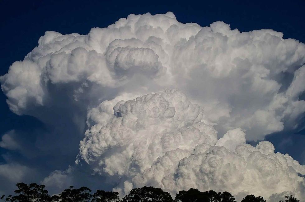
The cumulonimbus clouds are a more voluptuous version of the nimbostratus ones. These rain-bearing clouds bring in heavy rain to places lying below them.
The cumulonimbus develops a vertical structure, tapering and almost coming down towards the ground level that is a result of rapid evaporation and condensation of water vapor ushering thunderstorm events. These clouds are a mix of cumulus clouds and the rain-bearing nimbus clouds forming in the shape of dark cotton balls covering the sky.
Formation Of Nimbus Clouds
In general, all of the clouds in the sky form as a result of the processes of evaporation of warm air and water vapor and its condensation as water droplets that stick to each other forming masses of clouds.
The nimbus clouds are heavily laden with millions of water droplets that accumulate together in thick layers. The origin of nimbus clouds doesn't happen on its own.
The nimbostratus clouds form from the preexisting mid-level stratus cloud that comes down to the lower reaches and get laden with precipitation.
The cumulonimbus clouds start as altocumulus clouds or cumulus clouds that come down to the lower altitudes forming towering cauliflower-shaped or cotton ball-like clouds.
Both these nimbus cloud formation occurs in warm areas having a prominent low-pressure zone with high humidity or when at the intermixing zone of a cold and warm front.
The nimbostratus clouds are a result of the frontal mixing, wherein a cold air mass overlies a warm and moist area causing the warm air to rise quickly and the cold air sink down, speeding up condensation and the formation of a continuous layer of nimbus clouds.
The cumulonimbus clouds form as a result of rapid convection occurring in warm and humid low-pressure zone. Consequent to rapid evaporation of water vapor on a hot sunny summer afternoon the warm air cools rapidly forming towering dark clouds made of water droplets.
These clouds develop a vertical structure having a flat base with a towering formation at the top.

Qualities Of Nimbus Clouds
Nimbostratus clouds are dark and thick-layered clouds that cover up the whole sky and obstruct the sun rays from reaching the Earth's surface.
These clouds cover the sky uniformly and bring little to moderate intensity rain. The cumulonimbus cloud type brings thunderstorms with heavy rainfall and lightning or indicates an approaching hurricane.
The rays of the sun fail to penetrate these clouds and create a dark and gloomy ambiance. You can see snow falling in areas where the clouds are made of ice crystals as the underlying cold air determine the rate of condensation and protects the ice crystals or snow from melting and coming down in the form of rain.
Did You Know...
The high clouds are the cirrus clouds, cirrostratus clouds, and cirrocumulus clouds.
In Latin, cirrus means curls of hair, hence the white and wispy hair-like thin feathery clouds lying high above the sky are the cirrus clouds.
The cirrostratus clouds are a layered version of the cirrus clouds. These form white sheet-like clouds laden with thin ice crystals.
When the rays of the sun hit the ice crystals in the cirrostratus, they give a halo effect around the sun.
The presence of a few cirrus clouds high up in the sky indicates fair weather, devoid of precipitation.
The cirrocumulus is the thin and wispy broken clouds that cover the entire sky looking similar to that of fish scales and are thus called 'Mackeral skies'.
The mid-level clouds are the altostratus and altocumulus clouds. Among these two types of clouds, the altostratus cloud is found in light gray stripes and the altocumulus is found in uniform puffs in the sky.
Another classification using the cloud names can be done to describe the types of clouds, namely, the cumulus clouds, stratus clouds, and nimbus clouds.
The word cumulus means to form heap or look like a cauliflower. They have a vertical development and can be seen as low, medium, or high clouds in the form of cumulonimbus, stratocumulus, and altocumulus respectively.
Stratus clouds form horizontal layers spreading the entire sky because they are formed by warm air masses that rise up and condense forming various types of stratus clouds.
The cumulus clouds are also known as the watch clouds as they mostly come down from the higher to the lower levels owing to their vertical development in the layers of the sky forming cumulonimbus clouds that bring heavy spells of rain or snow.
All kinds of precipitation in the form of rain, hail, snow, or sleet come from the nimbus cloud. So identify clouds that bring any kind of precipitation as the nimbus or rain cloud.
The cumulonimbus cloud that brings hurricanes and intense thunderstorms is also known as an anvil-topped cloud as its height often exceeds 1312 ft (400 m), having a flat base near the ground and a towering heap at the top.
Apart from these clouds discussed in this article, there are numerous subtypes of these clouds, with each cloud reflecting varying qualities in terms of its color, shape, size, behavior, and area of formation.
Here at Kidadl, we have carefully created lots of interesting family-friendly facts for everyone to enjoy! If you liked our suggestions for what do nimbus clouds look like, then why not take a look at are rainbows real or acid rain facts?


We Want Your Photos!
More for You


See All
Bachelor of Arts specializing in English, Master of Arts specializing in English
Rajnandini RoychoudhuryBachelor of Arts specializing in English, Master of Arts specializing in English
With a Master of Arts in English, Rajnandini has pursued her passion for the arts and has become an experienced content writer. She has worked with companies such as Writer's Zone and has had her writing skills recognized by publications such as The Telegraph. Rajnandini is also trilingual and enjoys various hobbies such as music, movies, travel, philanthropy, writing her blog, and reading classic British literature.
Disclaimer
1) Kidadl is independent and to make our service free to you the reader we are supported by advertising. We hope you love our recommendations for products and services! What we suggest is selected independently by the Kidadl team. If you purchase using the Buy Now button we may earn a small commission. This does not influence our choices. Prices are correct and items are available at the time the article was published but we cannot guarantee that on the time of reading. Please note that Kidadl is a participant in the Amazon Services LLC Associates Program, an affiliate advertising program designed to provide a means for sites to earn advertising fees by advertising and linking to Amazon. We also link to other websites, but are not responsible for their content.
2) At Kidadl, we strive to recommend the very best activities and events. We will always aim to give you accurate information at the date of publication - however, information does change, so it’s important you do your own research, double-check and make the decision that is right for your family. We recognise that not all activities and ideas are appropriate for all children and families or in all circumstances. Our recommended activities are based on age but these are a guide. We recommend that these ideas are used as inspiration, that ideas are undertaken with appropriate adult supervision, and that each adult uses their own discretion and knowledge of their children to consider the safety and suitability. Kidadl cannot accept liability for the execution of these ideas, and parental supervision is advised at all times, as safety is paramount. Anyone using the information provided by Kidadl does so at their own risk and we can not accept liability if things go wrong.
3) Because we are an educational resource, we have quotes and facts about a range of historical and modern figures. We do not endorse the actions of or rhetoric of all the people included in these collections, but we think they are important for growing minds to learn about under the guidance of parents or guardians.