43 South America Geography Facts: Here's All That You Need To Know


Gallery
South America is a continent that is known to be the greenest.
The lungs of the earth, which are called the Amazon rainforest, are situated in South America. The most famous country on the continent is Brazil.
South America's geographical location is quite interesting to know about. There are many facts about the geographical location of South America that may surprise you. This means you can find different types of landmasses here in South America.
South America is considered the home of the two of the largest countries in the whole world. Also, the geography of South America has been dominated by the Andres mountain range and also the world’s second-largest river, which is the Amazon river.
South America is bordered by the Atlantic ocean from the east and the Pacific Ocean from the west, which is primarily located in the southern hemisphere.
It is interesting to note that South America has a geologic structure of dissymmetric parts. The western portion is majorly covered by the tallest mountain Andes, while the eastern portion is divided by the Amazon basin.
The geography of South America has a great range of elevation that brings out diversity in the ecological and climatic zones. We cannot deny the fact that this climatic fluctuation is one of the prominent characteristics of South America.
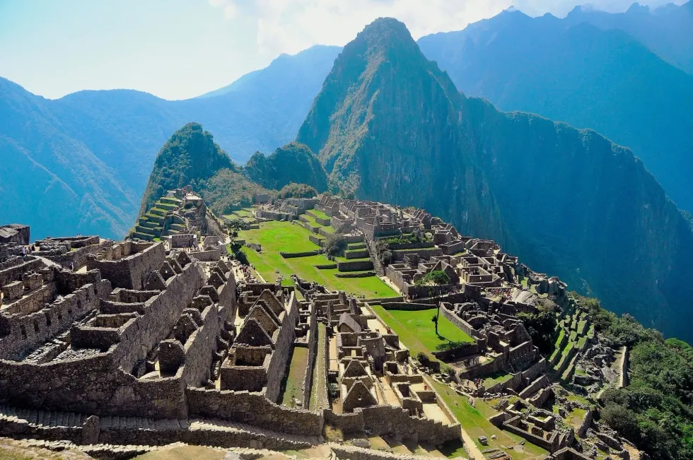
There are more than 20 world heritage sites in South America and the continent is filled with architectural wonders, national parks, and colonial centers apart from the rainforests, glacial lakes, mountains, and wetland ecosystem. One of the most popular heritage sites is in Peru. Yes, we're talking about the Machu Picchu.
Inca Ruins is probably on everyone's travel bucket list. Similarly, Galapagos Islands in Ecuador are popular for their unique ecosystem.
Names Of Countries In South America
South America is a greatly diversified continent with mixed ethnicity. There are a total of 12 countries in the continent of South America.
- These 12 countries have their beauty that makes South America a great place.
- The 12 countries of South America are Argentina, Bolivia, Brazil, Chile, Colombia, Ecuador, Guyana, Paraguay, Peru, Suriname, Uruguay, and Venezuela.
- Apart from these 12 countries, there are three territories in South America.
- The Falkland Islands and the South Georgia & South Sandwich Islands are called the Dependant territories.
- There is one internal territory, which is called French Guiana.
- Chile and Argentina are the most developed countries in South America.
How do geography and climate affect ways of life in South America?
So while we are talking about the geography of South America, it is well known that this country has a mixed landmass.
- You can find the coastal regions, highlands, grasslands, plateaus, and mountains in South America.
- Also, South America is divided into four climatic regions such as the tropical, temperate, arid, and cold.
- For example, Sao Paulo enjoys a temperate climate.
- The warmest in Sao Paulo is in the month of February.
- On the other hand, Rio De Janeiro has a tropical climate.
- One interesting fact about Rio de Janeiro is that there are only two seasons here: warm and humid.

Does South American geography affect its economy?
South American Geography speaks so much about its potential and the continent is home to huge biodiversity by nature.
- Geography seems to affect the economic policy choices here.
- There are many geographic regions that have high population densities.
- Anyone can easily see that south America has diverse agricultural products.
- The list includes vast mineral wealth and plentiful freshwater.
- The unequal distribution of population also contributes to the change in economic resource usage.
- For example, cocoa-growing areas in South America attract substantial in-migration.
- South America also has rich fisheries and ports on three different bodies of water, which are the Caribbean Sea, Atlantic ocean, and the Pacific Ocean.
- That’s why the continent’s economy is centered on the export of natural resources.
- The export business also plays the main role in the economy of South America, especially for many aspects of its development.
- Some very important cash crops, coffee and cacao, are dealt with in this export worldwide.
- You should know that Brazil is the world’s largest exporter of cacao.
The Four Main Geographical Regions Found In South America
The main four geographical regions which are found in South America are as follows.
- The list includes the coasts and the islands, the Andes mountains, the Guiana highlands, and the angel falls, and the last main one is the amazon river lowlands.
- Brazil covers 47.3% of the land area.
- Brazil is practically half the continent's population.
- The above-given divisions are the remaining countries and territories.
- The continent also includes some nearby islands.
- The island countries in the Caribbean are usually grouped as North American subregions.
- Areas like the Aves Island and Santa Catalina, usually administered by Venezuela and Colombia are parts of South American countries politically speaking.
- Naturally, there are several islands in these subregions.
- The continent has an isolated volcanic island.
- This Ascension Island is geopolitically, a part of Africa.
- A volcanic island administered by Norway shares territory with South America.
Fun Facts About South America's Geography
Some of the amazing and fun facts about the geography of South America are as follows.
- One of the amazing fun facts is that the amazon river is the longest river in the world and is present in South America.
- Did you know that the Amazon forest is the largest natural rainforest in the whole world?
- The second fun fact is that the driest place on the earth is the Atacama desert and it is in Chile, South America.
- The third one is about the beautiful Angel Falls in Venezuela. It is the tallest waterfall in the world. Also, let us not forget the Andes mountain, which is the longest continental mountain range in the whole world.
- Last but not least, this fact is about Ushuaia, in Argentina, which is commonly regarded as the southernmost city in the world and is popular for being the gateway to Antarctica.
- South America is a diverse continent, partly in the western hemisphere and mostly in the southern hemisphere and with a relatively small portion in the northern hemisphere.
- From the Andes Mountains, Angel Falls, Atacama Desert to Brazilian Highlands, Amazon Rainforest, and the Falkland Islands, everything here is simply fascinating.
- Being the fourth largest continent, and a part of the western hemisphere, the geography of the South American continent is definitely something to talk about.
- All South American countries have something to offer to the beauty of their geography.
- For example, the Andes Mountain range is the longest mountain range and this continental longest mountain range is the western coast of the continent.
- Likewise, Chile has the Atacama Dessert that is popular as the driest nonpolar desert in the world.
- Atacama desert is the only area to receive comparatively less precipitation than any polar desert.
- We cannot forget how Lake Titicaca has the best freshwater lake in the Andes.
- Being on the borders of Peru and Bolivia, Lake Titicaca is the world's highest navigable lake at 12,507 ft (3,812.3m).
- Speaking of the longest river, with a giant arc of 1700 mi (2735.9 km), we have the Orinoco River in the Parima Mountains.
- You might also not want to miss out on the Parana River and the Tocantins River.
- As such, Amazon River Basin occupies most of central and east South America and is one of the popular river basins.
- Amazon basin is the largest watershed in the entire world. Amazon is a huge attraction on this continent.
- The Amazon Rainforest covers nine nations within the borders, and a section of the forest was flooded by the Caribbean Sea several times.


We Want Your Photos!
More for You


See All
Bachelor of Arts and Law specializing in Political Science and Intellectual Property Rights
Anusuya MukherjeeBachelor of Arts and Law specializing in Political Science and Intellectual Property Rights
With a wealth of international experience spanning Europe, Africa, North America, and the Middle East, Anusuya brings a unique perspective to her work as a Content Assistant and Content Updating Coordinator. She holds a law degree from India and has practiced law in India and Kuwait. Anusuya is a fan of rap music and enjoys a good cup of coffee in her free time. Currently, she is working on her novel, "Mr. Ivory Merchant".
Disclaimer
1) Kidadl is independent and to make our service free to you the reader we are supported by advertising. We hope you love our recommendations for products and services! What we suggest is selected independently by the Kidadl team. If you purchase using the Buy Now button we may earn a small commission. This does not influence our choices. Prices are correct and items are available at the time the article was published but we cannot guarantee that on the time of reading. Please note that Kidadl is a participant in the Amazon Services LLC Associates Program, an affiliate advertising program designed to provide a means for sites to earn advertising fees by advertising and linking to Amazon. We also link to other websites, but are not responsible for their content.
2) At Kidadl, we strive to recommend the very best activities and events. We will always aim to give you accurate information at the date of publication - however, information does change, so it’s important you do your own research, double-check and make the decision that is right for your family. We recognise that not all activities and ideas are appropriate for all children and families or in all circumstances. Our recommended activities are based on age but these are a guide. We recommend that these ideas are used as inspiration, that ideas are undertaken with appropriate adult supervision, and that each adult uses their own discretion and knowledge of their children to consider the safety and suitability. Kidadl cannot accept liability for the execution of these ideas, and parental supervision is advised at all times, as safety is paramount. Anyone using the information provided by Kidadl does so at their own risk and we can not accept liability if things go wrong.
3) Because we are an educational resource, we have quotes and facts about a range of historical and modern figures. We do not endorse the actions of or rhetoric of all the people included in these collections, but we think they are important for growing minds to learn about under the guidance of parents or guardians.