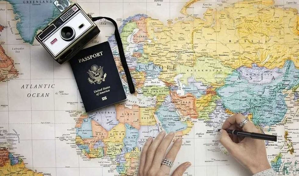
101 Cartography Facts For Kids To Learn About The Art Of Map Making


Gallery
The history of cartography consists of either mapmaking technology or developments in cartography.
Earlier maps that have survived are etchings and cave paintings on stone and tusk. Extensive maps created in ancient Babylon, India, China, Rome, and Greece have also survived.
Cartography consists of two Greek words. 'Chartes' meaning 'map', 'a sheet of paper', or 'papyrus', and 'graphein', meaning 'write'.
It is the practice and study of using and making maps. Cartography combines technique, aesthetics, and science, building on the hypothesis that reality can be shaped in a way that effectively conveys spatial details. Cartography today is made up of several practical and theoretical foundations of GISc, or Geographic Information Science, and GIS, or Geographic Information Systems.
Cartography Facts
A set of countries wanted an international map in 1891 to produce a standard set of maps for the world. This initiative continued until the '80s, when the world faced the Great Depression and the World Wars.
- Medieval Latin words, 'Mappa Mundi', marks the origin of the world map. 'Mappa' means 'cloth' and 'Mundi' means 'world'.
- Since the sixth century BCE, ancient Romans and Greeks have created maps.
- In 1507, Martin Waldseemuller created a 12-panel huge global wall map and a globular world map, in which the name 'America' was first used.
- Major western maps in the medieval ages placed the east on the top. The word 'east' is 'oriens' in Latin and for the east to stay east they had to orient the map.
- The first map of Africa was drawn by James Rennell in 1798, illustrating the giant Mountains of Kong.
- The oldest sphere, dating from 1,504, was engraved on an ostrich egg.
- Not every place on the map exists. For example, the Mountains of Kong do not exist.
- Paper maps are still used by people, and the largest atlas in the world is Earth Platinum.
- Modern cartographers make sure to include fake places and towns in their maps.
- Argleton in England is a fake town or paper town created by Google.
- Rudimentum Novitiorum, an encyclopedia, was the first printed map.
- The first road map was a map of Egypt called the Turin Papyrus, created around 1160 BC.
- In the mid-16th century, Gerardus Mercator created the current world map that we are familiar with, called the Mercator projection.
- The Kangnido map, created by Kwon Kun, a Korean in 1402, was the first to establish the North on the top with the South placed at the bottom.
- America got its name from a cartographer called Amerigo Vespucci.
- A common practice throughout history and even today is map censorship.
- Around the '30s, at American gas stations, maps were provided for free.
- The word 'globe' comes from 'globus', a Latin term meaning 'a round mass or sphere'.
- The Bibliotheque Nationale de France in Paris has the world's best map collection.
- The oldest discovered map was not of our planet but of the stars.
- The celestial globes pay more attention to the position of the stars in the night sky than the planets, the Sun, or the Moon.
- Hobo-Dyer is used by experts for accuracy and scales.
- A map reader determines the patterns and symbols on a map.
Importance Of Cartography
For humans to analyze and understand spatial relationships and later be able to make decisions based on them, they will need cartography. Maps impact urban planning, disaster relief, transportation, and natural resource distribution.
- People can make preoccupied duplications of physical spaces that they use to figure out these spaces.
- People make use of maps to move toward the desired location and comprehend the most economical way to travel between these spaces.
- It also gives information about the things found in different spaces, be it a river or a store.
- Cartography allows people to improve different features of society on a large scale.
- Maps also show transportation systems, resources, and population beyond rivers, mountains, and seas.
- People make decisions about resource distribution, like power lines or oil pipelines, using cartography.
- Urban planning, like a new line of transportation, also requires the use of cartography.
- Cartography also plays a role during disaster relief. When a natural disaster like an earthquake or tsunami occurs, relief agencies use maps for assessing the situations, staying aware of ground changes, and detecting relief routes.
- During disasters, government planners also make use of maps to detect the appointed escape routes.
- A normal human needs to use a map or google maps on a day-to-day basis and it is usually not complicated.
- Maps represent various locations and landmarks with symbols, and no special artistic skill is needed for map makers and map users.
- The art of cartography and ancient maps have existed since ancient times and are depicted in cave paintings (an engraved map).
- In the Lascaux caves in France, a map of stars was found, believed to be almost 16,500 years old.
- In the mid-19th century, when London faced a cholera outbreak, John Snow created a map of cholera cases in the affected regions and was able to determine the source of the cholera-causing water pump.
- Over the last century, the volumes of geographic data have increased, with which the necessity and use of thematic maps has increased for interpreting social, cultural, and spatial data.
- A map projection is a method of flattening the surface of the globe into a plane to make a map.
- The earliest maps date back to the seventh millennium BCE, one of which was a wall painting possibly depicting Catalhpyuk, an ancient Anatolian city.
- During the Renaissance, maps were used for wayfinding and navigation.
- Maps were also used for property management, land surveying, and general descriptions.
- Written directions were more common than the use of maps during the middle ages.
- After the Renaissance, political leaders could claim territories by using maps, which was aided by colonial and religious expansion.
- Religious places like the Holy Land were the most commonly mapped locations during the Renaissance.
- A map's purpose can be as small as asking your neighbor to move the fence or as big as teaching the major political and physical characteristics of our world.
- Not only will cartography help maintain maps, but it will also make it easier for people to update maps.
- Cartography allows you to represent both graphical and symbolic data.
- Cartography also makes it easier for people to represent one region on a small piece of paper.
Cartography Tools
Cartography tools allow you to create precise maps that would help current and future generations. For many years throughout history, cartographic tools have been used. However, modern cartography tools vary greatly compared to the ones in ancient history.
- Unlike the modern-day map, the first map was constructed manually.
- Common cartographic tools are rulers, calipers, pairs of compasses, ink, quills, and parchment.
- Later years saw improved magnetic devices, allowing people to create accurate maps and edit them digitally.
- Mechanical devices improved, producing verniers, quadrants, and printing presses, helping people produce maps in bulk.
- The use of telescopes and other optical devices helped people to survey land and navigators and mapmakers were able to find their latitude.
- The latitudes are determined by measuring the angles to the sun at noon or the night sky's North Star.
- Photochemical and lithographic processes have allowed people to make water-resistant maps that do not alter in shape, and have fine details.
- Engraving was not a necessity after these methods were introduced, shortening the time that it takes to produce or reproduce maps.
- Remote sensing, satellite imagery, and aerial photography developed in the 20th century provided effective mapping methods of physical features like topography, watersheds, buildings, roads, and coastlines.
- Another great change that guided the art of cartography forward was the advancement of electronic technology.
- The expansion of map-making was supported by the availability of peripherals and computers, like plotters and printers, with computer programs for image processing and visualization.
- The process of superimposing spatial locations on existing maps brought new uses for maps.
- Modern-day commercial maps are created with software like specialized illustration software, GIS, and CAD.
- Databases in modern software store spatial information that can be extracted at any time.
- Early aerial photography attempts were kites, balloons, and rockets too.
- James Wallace Black took the oldest currently surviving photograph in 1860, restrained at 2,000 ft (0.6 km) in a hot air balloon above Boston.
- Today's aerial photography tools include UAVs, or Unmanned Aerial Vehicles, commonly known as drones and helicopters.
- Drones are great, particularly for GIS mapping and consistent large-scale visual records.
- Sensors detect the physical characteristics, changes, and events of an area by converting stimuli into electrical signals.
- Sensors used for cartography are sonars to detect things underwater, LIDAR for serial mapping using 3D lasers, and seismometers for measuring ground motion.
- Sensors are particularly used to compare discrepancies between two maps of an area.
- The popular GPS, or Global Positioning System, uses more than 24 satellites orbiting our Earth continuously, with unique data from each of them.
- GPS is used both for land surveying and for navigation in mobile phones, boats, cars, and aircraft.
- Without satellites, the GPS would not work. Satellites also improve cell service and track weather.
- As satellites have increased the range and speed of mapping, surveys can be finished in a matter of minutes.
- The GIS, or Geographical Information System, manages, organizes, and displays the data collected by satellites, GPS, and sensors.
- Spatial intelligence, or location intelligence, allows users to understand the necessary relationships in geospatial data.
- 3D models of maps can be created using the LIDAR tool, which uses a laser to measure distance.
- LIDAR releases the laser outwards, and it then hits an object and bounces back. By measuring the time taken by the laser to return, the distance is derived.
- Real-time digital mapping allows various activities like tracking your taxi on your phone or tracking service inspections.
Types Of Cartography
The display of variables and types of information on maps can vary. There are many types of maps around the world. However, the basic maps are general, topographic, and thematic maps.
- General and thematic maps are the two general categories of maps in cartography.
- General reference maps are made for the general audience and consist of many features.
- General maps are created in series and exhibit several location systems and references.
- Thematic mapping consists of creating maps of particular geographic themes for a specific audience.
- Due to the increase in geographical data, the necessity and use of thematic cartography have increased over the previous century.
- The special-purpose map, also called the orienteering map, falls between general and thematic maps.
- The orienteering maps are designed using thematic map attributes and general elements for a particular group of audiences.
- Usually, orienteering maps are made for a specific occupation or industry.
- The topographic map mainly involves topographic descriptions of a place.
- The relief or terrain on a topographic map can be illustrated in many ways.
- Today, we use computer software to develop an elevation model showing shaded relief on a topographic map.
- Eduard Imhof, a Swiss professor, was regarded as the master of creating headed relief by hand.
- Although Eduard's efforts in hill shading were so labor-intensive, they were used across the world.
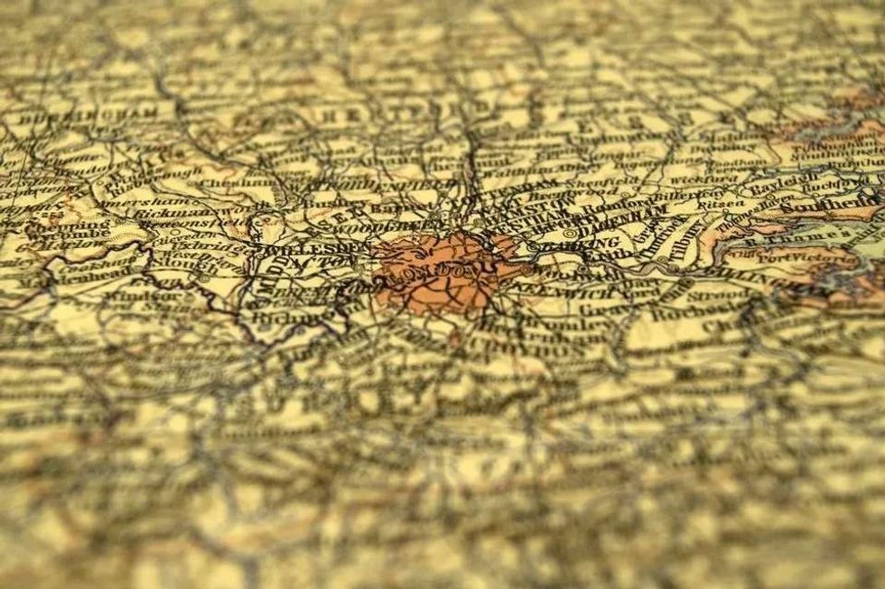
- A general map called a topological map is generally the one that is sketched on napkins.
- A topological map usually overlooks the details and scale and is only created to convey a particular route or its information. It is not an accurate map.
- The London Underground Map by Henry Beck is a popular example of a topological map.
- Distribution maps consist of continents, countries, or states broken down into regions.
- The distribution map contains illustrations of the distribution of anything from crops and farms to exports and imports.
- Historical maps represent influential events and feature some geographical elements to provide information to the map reader about the impact of these events around the region.
- Historical maps also have dates of events as their title or caption.
- Historical maps often show routes taken by pioneers or explorers, battles, volcanic eruptions, historical landmarks, and inventions by inventors.
- Physical maps display the natural features of our planet Earth.
- The physical map contains geographical landforms like grasslands, mountains, and oceans.
- Political maps display the time zone differences and boundaries between countries, states, and counties.
- A political map usually includes major highways, capital cities, and major cities, as well as features shared by these countries.
- Road maps show only the major roads of a country.


We Want Your Photos!
More for You


See All
Bachelor of Engineering specializing in Aeronautical/Aerospace Technology, Master of Business Administration specializing in Management
Arpitha RajendraBachelor of Engineering specializing in Aeronautical/Aerospace Technology, Master of Business Administration specializing in Management
With a background in Aeronautical Engineering and practical experience in various technical areas, Arpitha is a valuable member of the Kidadl content writing team. She did her Bachelor's degree in Engineering, specializing in Aeronautical Engineering, at Nitte Meenakshi Institute of Technology in 2020. Arpitha has honed her skills through her work with leading companies in Bangalore, where she contributed to several noteworthy projects, including the development of high-performance aircraft using morphing technology and the analysis of crack propagation using Abaqus XFEM.
Disclaimer
1) Kidadl is independent and to make our service free to you the reader we are supported by advertising. We hope you love our recommendations for products and services! What we suggest is selected independently by the Kidadl team. If you purchase using the Buy Now button we may earn a small commission. This does not influence our choices. Prices are correct and items are available at the time the article was published but we cannot guarantee that on the time of reading. Please note that Kidadl is a participant in the Amazon Services LLC Associates Program, an affiliate advertising program designed to provide a means for sites to earn advertising fees by advertising and linking to Amazon. We also link to other websites, but are not responsible for their content.
2) At Kidadl, we strive to recommend the very best activities and events. We will always aim to give you accurate information at the date of publication - however, information does change, so it’s important you do your own research, double-check and make the decision that is right for your family. We recognise that not all activities and ideas are appropriate for all children and families or in all circumstances. Our recommended activities are based on age but these are a guide. We recommend that these ideas are used as inspiration, that ideas are undertaken with appropriate adult supervision, and that each adult uses their own discretion and knowledge of their children to consider the safety and suitability. Kidadl cannot accept liability for the execution of these ideas, and parental supervision is advised at all times, as safety is paramount. Anyone using the information provided by Kidadl does so at their own risk and we can not accept liability if things go wrong.
3) Because we are an educational resource, we have quotes and facts about a range of historical and modern figures. We do not endorse the actions of or rhetoric of all the people included in these collections, but we think they are important for growing minds to learn about under the guidance of parents or guardians.