Located in the Northwest Territories of Canada, Nahanni National Park Reserve is a UNESCO Heritage Site.
The South Nahanni River that is located in this park is one of the most breathtakingly beautiful rivers in North America. A part of the Mackenzie Mountains Natural Region, a WWF global eco-region, can also be found in this park.
The Nahanni National Park Reserve covers an area of about 11,602 sq mi (30,050 sq km).
Nahanni National Park is open to visitors all year round, however, most people come here between June and August. Also, Virginia Falls and Glacier Lake are the only spots that can be enjoyed, as day trips to all other places within the park require an overnight stay.
There's plenty to do in Nahanni National Park. You can paddle up the Nahanni River to Virginia Falls. It is also a popular destination for climbers, and the main areas for this activity include the Cirque of the Unclimbables and the Lotus Flower Tower.
In addition to the river, there are many lakes that offer excellent opportunities for fishing. The trails up Ram Creek and Sheaf Creek are perfect for hiking. You can also just sit back and relax and take in the breath-taking and scenic views.
Geography
Nahanni National Park is located at the southwest corner of the Northwest Territories in Canada. It is 80.7 mi (130 km) southwest of Fort Simpson.
The various types of landforms in this park have formed over millions of years. The rocks here are the result of the sediment of an old inland sea that was present here more than 500-200 million years earlier.
This sediment was pressed over time, which resulted in the rock formations. The mountainous ranges, such as the 'Ragged Range,' are the result of these rocks being layered and pushed upwards that occurred when the North American and Pacific plates collided with each other.
The South Nahanni River, which starts at the Moose Ponds, is the main feature of the park. This river flows through the Franklin, Selwyn, and Mackenzie mountains and covers the full length of the park, until the Nahanni Butte, where it then flows into the Liard River.
An interesting fact about this river is that it has stayed its course after all this time and even as mountains have risen around it. This means that the path it flows on today is the same as the one that it followed before the mountainous ranges were formed.
This is an extremely rare occurrence for a river; thus, it is known as an antecedent river.
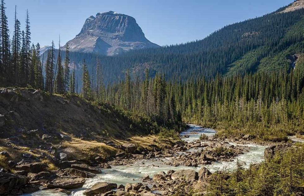
The Nahanni River has carved a beautiful valley through the Mackenzie Mountains. The Mackenzie Mountains are also full of caves and gorges that have been created by the Nahanni River washing away the limestone soil over the years.
For most of its length, the Nahanni River is lined with deep and majestic canyon walls. There are many canyons along the path of the South Nahanni River. However, the four main ones have been named by people who came to this area seeking gold.
The Painted Canyon, also known as the Five Mile Canyon, is named because of its length. It is also the most well-known of these river canyons. It is where the popular tourist attraction, Virginia Falls, begins.
The third canyon is different from the others, as it has long slopes and its end is marked by the 45-degree turn that the river makes, which is known as the Big Bend. The first canyon that starts at Deadmen Valley is said to be the most majestic and prettiest of all, and it also has the highest walls.
The highest mountain in the Northwest Territories is Mount Nirvana, which is officially an unnamed peak. It stands at 9,098 ft. (2,773 m).
When the park was expanded in 2009 by the government of Canada, it came to include some of the largest ice fields in the Northwest territories.
The climate of this area is classified as cold continental. The average precipitation that occurs here between June and August is 2.3-3.5 in (60-90 mm). Severe thunderstorms are quite common in July.
Virginia Falls & Rabbitkettle Hot Springs
Located on the South Nahanni River, 75 mi (120 km) from the Yukon border, Virginia Falls is double the height of Niagara Falls. The river plunges in a single drop of 315 ft (96 m). Virginia Falls has a width of 850 ft (259 m).
Mason's Rock, named after the Canadian author, film-maker, and canoeist, Bill Mason, is located at the center of the falls. The spray and mist created as the river plunge down the canyon have caused quite a few rare species of orchid to grow and thrive in the area surrounding Virginia Falls.
People can visit Virginia Falls through day trips from Fort Simpson to the park by floatplane.
Figure Eight, Lafferty's Riffle, and George's Riffle are a few of the rapids that are located downstream from Virginia Falls.
The Virginia Falls Water Aerodrome is also located nearby.
Rabbitkettle is a tufa mound that is located in the valley at the base of the Ragged Range. The Rabbit Kettle Hot Springs has its source deep down in the Earth's crust near the Ragged Range.
The same volcanic activity that resulted in the formation of the mountains in this park is what still warms the water. The pools of water are of varying sizes, and some of them can be as small as a fingernail to being as large as a bathtub.
The tufa mounds, which are soft rocks made of calcium carbonate, are the largest in Canada. The North Mound, standing at 89 ft (27 m) high and 243 ft (74 m) wide, is the largest mound here.
Flora And Fauna
The flora and fauna in the park is the richest and most diverse of the Northwest Territories in Canada.
The vegetation of Nahanni National Park is classified as a boreal forest. However, the many ecosystems here range from wet lowlands to alpine tundra.
The many different types of soil in various parts of the park have made it home to more than 700 species of plants and 300 species of lichen.
The white and black spruce, subalpine fir, balsam poplar, and trembling aspen are the main tree species that can be found in this area. A rare aster species known as the Nahanni aster can only be found in this national park.
Wild cherries, roses, and ferns grow near and around the area of the hot Sulphur springs as the ground here never freezes due to the heat.
There are many different types of animals that live in Nahanni National Park. There are 42 types of mammals, 180 kinds of birds, 16 types of fish, and some amphibian species that can be found here according to Parks Canada. Some of these include wolves, black and grizzly bears, mountain goats, and woodland caribou.
The park is also home to some threatened and endangered species of birds, animals, and fish. They include the grizzly bear, rusty blackbird, and the woodland caribou.
The birds found here are the bald and golden eagles, trumpeter swans, and the American kestrel. Nahanni National Park is also the only nesting place of the whooping crane.
The fish species found in the many lakes here, including Glacier Lake, are the bull trout, longnose dace, lake trout, and northern pike.
A World Heritage Site
The park was established by Prime Minister Pierre Elliot Trudeau in 1972 and was among the first four natural locations to be declared a World Heritage Site by UNESCO in 1978. The other sites were the Galápagos Islands in Ecuador, Simien National Park in Ethiopia, and Yellowstone National Park in the United States.
The stunningly beautiful rivers, jaw-dropping waterfalls, and canyons are what have made this region a heritage site.
This park in Canada was added to the UNESCO list of sites under criteria (vii) and (viii), which states that to qualify, the site should have exceptional natural beauty and significant landforms.
Although, in 2009, under the Canada National Parks Act, additional land area was added to the park, the boundaries of the heritage site remain the same. Therefore, the Nahanni National Park Heritage Site is now located within the Nahanni National Park Reserve.
Other Miscellaneous Facts
Here's a brief history about the park and the area surrounding it.
The area of this park has been used by humans for many years. It has been estimated that humans first occupied this land about 9,000-10,000 years earlier. The Naha tribes and the Dene people have stayed in this dangerous landscape for many years.
In the 18th century, European fur traders arrived in the region. The Scottish explorer, Alexander Mackenzie, built the first trading posts at Fort Liard and Fort Simpson.
In the 19th century, permanent settlements were set up at these trading posts and at Nahanni Butte by the Dene people.
During the Klondike Gold Rush between 1896-1899, some explorers and prospectors tried to use this area to get to the goldfields in the Yukon and to try to find gold in the south Nahanni River.
Although no gold was found, there are many legends and stories of how this area has been haunted. It is through these legends and stories that many of the land features of the park got their names. These landforms include the Funeral Range, Headless Range, and Deadmen Valley.
The following are a few interesting facts about the park:
Ancient skeletons of Dall's sheep, a type of sheep species found in Northern America, have been found in caves such as Grotte Valerie. This cave system is also among the best in the world. However, it is closed to visitors.
Nahanni National Park has no public roads and can only be accessed by air or by hiking. To visit Nahanni River, you would need to use a floatplane operated by the charter companies in Fort Simpson.
This area has been featured in quite a few literary works, including 'Sick Heart River' by John Buchan, a British novelist. 'The River', a book about the legends and stories of the area, by Cheryl Kaye Tardif is another one that features this park.
A French work, 'La Vallée Sans Homme', by Roger Frison-Roche, written in 1973, was also set in the area around the Nahanni River.
FAQs
Why is Nahanni National Park important?
A: Nahanni National Park is important as it has a beautiful and wild landscape that has been untouched for many years. It is also for this reason that it has been declared a heritage site by UNESCO.
A: How many people have died in Nahanni National Park?
There have been many mysterious deaths in this rugged landscape, especially of those seeking or mining for gold. Among the first corpses to be found in this area were those of prospectors Frank and Willie McLeod in 1908.
Hence, many of the lands featured here, such as Deadmens Valley, get their names from the legends and stories from these deaths.
A: What does the name 'Nahanni' mean?
The name 'Nahanni' is derived from the indigenous people of the region of Dene. It means 'the river of the Nahʔa people.'
A: Where is Nahanni National Park located?
Nahanni National Park is located in Canada in the Dehcho Region of the Northwest Territories. It is about 311 mi. (500 km) away from the city of Yellowknife.
A: Why and when was Nahanni National Park declared a World Heritage Site?
Nahanni National Park was added to the heritage list of UNESCO because of its remarkable and outstanding natural beauty in 1978.