61 Savannah River Facts: Learn About This Interesting River!


Gallery
The Savannah River is a major river in the southeastern United States and is known to form most of the border between the states of Georgia and South Carolina.
Two tributaries of the Savannah River include the Chattooga, and the Tugaloo rivers, which constitute the northernmost border of the states. The Savannah River has a length of around 301 mi (484 km) and was formed by the confluence of the Seneca River and the Tugaloo River.
The confluence of the above-mentioned rivers is now hidden beneath Lake Hartwell. The northwest branch of the Savannah River is formed by the Tallulah River, a tributary of the Tugaloo River.
Tallulah River is where the Tallulah Gorge is located. Bounded by the Eastern Continental Divide, the Savannah River basin travels to the southeastern part of the Appalachian Mountains just inside North Carolina.
There are two main cities that are found along the Savannah River - Augusta (Georgia) and Savannah. During the colonial period set in the United States, these two cities were the center of early English settlements.
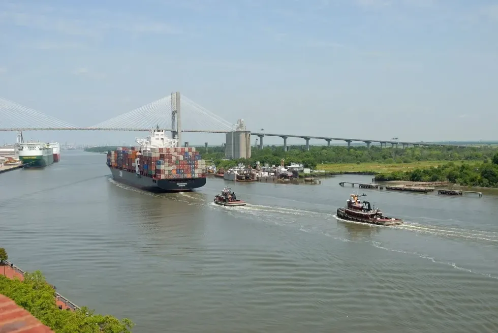
At Savannah, the Savannah River is known to be tidal, but as we go downstream from there, the Savannah River broadens into an estuary and then flows into the Atlantic Ocean. The area where the estuary of the Savannah River system meets the ocean is called Tybee Roads.
Near the city of Savannah, the Intracoastal Waterway flows through a part of the Savannah River.
The watershed of the Savannah River basin is 10,577 sq mi (27394.3 sq km). The Savannah basin starts from the mountains of North Carolina, South Carolina, and Georgia.
The Savannah basin originates near Ellicott Rock where the three states meet. The western part of the upper basin sees the Chattooga River and Tallulah River meet and form the Tugaloo River.
And in the eastern side, Twelve Mile Creek and the Keowee River join to form the Seneca River. In the upper parts of Lake Hartwell, Tugaloo and Seneca rivers join each other to form the Savannah River.
The upper parts of the river system have manmade lakes like Russell Lake, Hartwell Lake, Clarks Hill Lake, and Thurmond Lake.
The Savannah River flows through Blue Ridge Mountains, Piedmont, Upper Coastal Plain, and Lower Coastal Plain, and on the way, the Savannah River basin is filled with upland forests, scenic rivers, agricultural tracts, swamplands, pine plantations, free-flowing streams and creeks, and marine and freshwater marshes.
The route of the river is very aesthetic and has a lot to offer in terms of natural beauty.
The lower part of the Savannah River basin however has a moving course of few tributaries having slow currents. Before flowing into the Atlantic Ocean, the Savannah River broadens.
The Savannah River is very important as it provides drinking water to some major metropolitan areas of Georgia. In fact, the Georgia River network constituting the Savannah River is crucial for the survival of the cities that gets the water from the Savannah River. Some coastal cities of South Carolina also depend on the Savannah River for drinking water.
The river has been known to be a major transportation corridor for most industrial and commercial uses. The river also helps in power generation and is quite important for the area in North Carolina and South Carolina.
The river supplies water to the Savannah River Site in South Carolina. This area of South Carolina also includes the Savannah River Ecology Laboratory.
The river also provides water for cooling the nuclear reactors at Plant Vogtle, an electricity generating station. Savannah Harbor, the country's fourth-largest seaport stands on this river and makes the Savannah River a major hub for transportation.
Even for recreational use, the Savannah River basin provides a wide range of opportunities. There are beautiful waterfalls and fast-flowing streams popular for rafting and kayaking. The lakes in the upper stream are known for their size and natural beauty.
You can swim, fish, camp, and do much more on these natural lakes. Many water sports, sailing, and power boating are very popular in the region. These activities with much fishing and canoeing not only amuses the various visitors but also add to the economy of the region.
Fun Facts About The Savannah River
Let's read some fun facts about the Savannah River and the Savannah basin everyone talks about.
For knowing about the facts of the Savanah River and the Savannah basin, it is important to know a little about the history of the river and the nearby areas.
The Savannah River has been given many different names including May River, Westobou River given by the Westo tribe, Isundiga River, Girande River, and Kosalu River. The river was formerly known as the Westobou River and the name came from the Westo Native Americans.
This tribe was thought to be from the northeast and was pushed away from that region by the more powerful tribes.
The migration began in the late 16th century and the Westo Indians reached the current region of Augusta, Georgia around the 1660s.
The river was used by the tribe for trade, fishing, transportation, and water supplies. The Spanish colonists tried to come to this region from Florida, but the Westo Indians were strong enough to hold their ground and push the Spaniards away.
The Carolina Colony lived in the region and needed an alliance with the Westo tribe for protection. But when the colony wanted to expand their trade to Charleston, they saw the tribe as an obstacle, and to eradicate the problem, the Carolinians hired a group named Goose Creek Men to fight the Savannah Indians.
This tribe defeated the Westo tribe in the 1680 Westo War.
The English colonies then named the river Savannah. The river was a crucial part of the early development of the region and the community as well as the Savannah River basin.
During the colonial era, the English founded two major cities on the Savannah River. Savannah was first established in 1733 as a seaport on the Atlantic Ocean and then came Augusta in Georgia which was created where the river passes the Fall Line of Piedmont.
It was located at the headwaters of the Savannah River basin that can be navigated, downstream to the Atlantic Ocean. The two cities on the Savannah River acted as the first two state capitals of Georgia.
During the Civil War, American President Abraham Lincoln created a blockade around the Confederate States of America, and due to this, the harbor at the Savannah River basin became one of the busiest ports for people bringing in the supplies for the Confederacy. It was later cut off.
During the '50s, the construction of the Savannah River Plant of the U.S. Government started for the production of plutonium and tritium for nuclear weapons.
It was quite a significant time for the river. Between the years 1946 and 1985, three major dams were built on the Savannah for flood control, hydroelectricity, and navigation by the U.S. Army Corps of Engineers.
The Hartwell Dam in 1962, the J. Strom Thurmond Dam in 1954, and Richard B. Russell in 1985 combine with their reservoirs to form around 120 mi (193 km) of lakes.
The Savannah River Basin in North Carolina is home to many rare plants, animals, and birds. The thundering waterfalls in the region of North Carolina are pretty well known all over the world.
The Savannah River basin is shared with South Carolina and Georgia. The Savannah River basin is the smallest river basin in North Carolina.
There are 198 mi (319 km) of streams and 691 ac (279.64 ha) of lakes located in North Carolina. The upper basin receives around 100 in (254 cm) of rain annually, which makes it the wettest place in the Eastern United States.
So visit the Savannah River basin for an experience of a lifetime with the waterfalls and the natural wildlife growing in North Carolina. There are 32 rare species of critters and plants in the region.
Tropical weather brings tropical plants to the region. Pringle's aquatic moss is commonly seen in the waters clinging onto the rocks.
At the Russell Dam, the river is impounded along the upper part to form lake Richard B. Russell. There are also other reservoirs along the upper part of Savannah like Lake Hartwell and Clarks Hill Lake. Clarks Hill Dam, is located 22 mi (35 km) north of Augusta, Georgia
The main tributaries of the Savannah River are the Brier Creek and the Broad and Little rivers.
About 28 mi (45 km) upstream from where the Savannah joins the Atlantic Ocean, saltwater begins blending with the river's freshwater to form an estuary
What region is the Savannah River in?
To form the Tugaloo River, Chattooga and Tallulah Rivers join the Savannah River. And traveling downstream, the Tugaloo River joins with the Seneca River (South Carolina) to form the Savannah River. The Savannah River flows towards the southeasterly direction to empty into the Atlantic Ocean.
The Savannah River is one of the longest and largest waterways of Georgia. Most of the boundary between Georgia and South Carolina is defined by the Savannah River.
The river begins in the Piedmont geologic province, while the tributaries headwaters begin on the southwestern slopes of the Blue Ridge geologic province of Georgia, South Carolina, and North Carolina. Only 6% of the drainage basin lies in the Blue Ridge. The rest lies in Piedmont and the Upper and Lower coastal provinces.
From Lake Hartwell, the Savannah River flows in the southeasterly direction for 313 mi (503.72 km) across Piedmont and the Upper plains until it empties in the ocean. This is around 15 mi (24.1 km) downstream from Savannah city.
The river originates in the mountains and flows across the coastal plains to mix with the Atlantic Ocean. The river is known to transport large amounts of sediments which helps prepare the coastal plains and also elevates the life of the river.
On the journey towards the ocean, the Savannah River flows through agricultural lands, forests, hydroelectric reservoirs of massive sizes, and swamps. It is very well known for the high river bluffs. Some of these bluffs were the areas of Native American villages of prehistoric times.
Located in eastern Georgia and western South Carolina, the Savannah River basin defines the boundary between South Carolina and Georgia. The Savannah River basin is a total of 10,577 sq mi (27,342.5 sq km).
Of this, the Savannah River basin is 5821 sq mi (15,076.32 sq km) in eastern Georgia, 175 sq mi (453.2 sq km)in southwestern North Carolina, and 4581 sq mi (11,864.74 sq km) in western South Carolina. People even say that this basin has enough biodiversity to rival that of a South American region.
The Savannah River is known to flow through a variety of climates and ecosystems during its run. The Savannah basin drainage covers an area of 10,577 sq mi (27342.5 sq km) and carries large amounts of sediments to the Atlantic Ocean.
Facts About The Savannah River's Importance
The Savannah River is quite important for the survival of some cities in its route and also for big industries and nuclear plants.
The Savannah River provides drinking water to two major metropolitan areas - Augusta, in Georgia, and Savannah. The river also assimilates its wastewater.
Not only to these cities but the river Savannah also provides drinking water to the cities of Hilton Head and Beaufort in South Carolina and other smaller municipalities found in the area.
The river also supplies water to the Savannah River Site which includes two nuclear reactors of Plant Vogtle and Savannah River Ecology Laboratory in South Carolina. Plant Vogtle is a big electricity generating facility run by the Georgia Power Company in Burke County.
The Savannah River is also the shipping route for the Savannah port. This port is the country's 10th busiest port for container ships going to the ocean and is run by the Georgia Ports Authority.
Before the river empties into the ocean, it forms a network of salt marshes, tidal creeks, and freshwater marshes. This culminates to form the Savannah National Wildlife Refuge, a prime location for bird-watchers.

Width And Depth Of The Savannah River
The width of the river varies from place to place as it is wider in some regions and very narrow and shallow in some parts along the course.
The total length of the Savannah River is 301 mi (484.4 km). The maximum depth of the river is 42 feet (12.8 m). It is navigable for shallow draft and traffic from the river's mouth to Augusta. For ocean ships, the distance is from the mouth to 5 mi (8 km) above Savannah.


We Want Your Photos!
More for You


See All
Bachelor of Arts specializing in English
Ritwik BhuyanBachelor of Arts specializing in English
A skilled content writer, Ritwik holds a Bachelor's degree in English from Delhi University. He has refined his writing abilities through his past experience at PenVelope and his current role at Kidadl. In addition to his proficiency in writing, Ritwik has pursued his passion for flying by achieving CPL training and becoming a licensed commercial pilot. This diverse skill set highlights his commitment to exploring multiple fields. Ritwik's experience in the aviation industry has provided him with a unique perspective and attention to detail, which he brings to his writing.
Bachelor of Commerce

Niyati ParabBachelor of Commerce
With a background in digital marketing, Niyati brings her expertise to ensure accuracy and authenticity in every piece of content. She has previously written articles for MuseumFacts, a history web magazine, while also handling its digital marketing. In addition to her marketing skills, Niyati is fluent in six languages and has a Commerce degree from Savitribai Phule Pune University. She has also been recognized for her public speaking abilities, holding the position of Vice President of Education at the Toastmasters Club of Pune, where she won several awards and represented the club in writing and speech contests at the area level.
Disclaimer
1) Kidadl is independent and to make our service free to you the reader we are supported by advertising. We hope you love our recommendations for products and services! What we suggest is selected independently by the Kidadl team. If you purchase using the Buy Now button we may earn a small commission. This does not influence our choices. Prices are correct and items are available at the time the article was published but we cannot guarantee that on the time of reading. Please note that Kidadl is a participant in the Amazon Services LLC Associates Program, an affiliate advertising program designed to provide a means for sites to earn advertising fees by advertising and linking to Amazon. We also link to other websites, but are not responsible for their content.
2) At Kidadl, we strive to recommend the very best activities and events. We will always aim to give you accurate information at the date of publication - however, information does change, so it’s important you do your own research, double-check and make the decision that is right for your family. We recognise that not all activities and ideas are appropriate for all children and families or in all circumstances. Our recommended activities are based on age but these are a guide. We recommend that these ideas are used as inspiration, that ideas are undertaken with appropriate adult supervision, and that each adult uses their own discretion and knowledge of their children to consider the safety and suitability. Kidadl cannot accept liability for the execution of these ideas, and parental supervision is advised at all times, as safety is paramount. Anyone using the information provided by Kidadl does so at their own risk and we can not accept liability if things go wrong.
3) Because we are an educational resource, we have quotes and facts about a range of historical and modern figures. We do not endorse the actions of or rhetoric of all the people included in these collections, but we think they are important for growing minds to learn about under the guidance of parents or guardians.