68 Stunning Athabasca Glacier Facts You Should Know


Gallery
There is a Starbucks shop and two other restaurants at the center of the Athabasca Glacier.
The Athabasca Glacier is a unique natural wonder that deserves protection for future generations of Canadians and visitors alike. There are a few things that you can do on your own, such as reducing your reliance on fossil fuels.
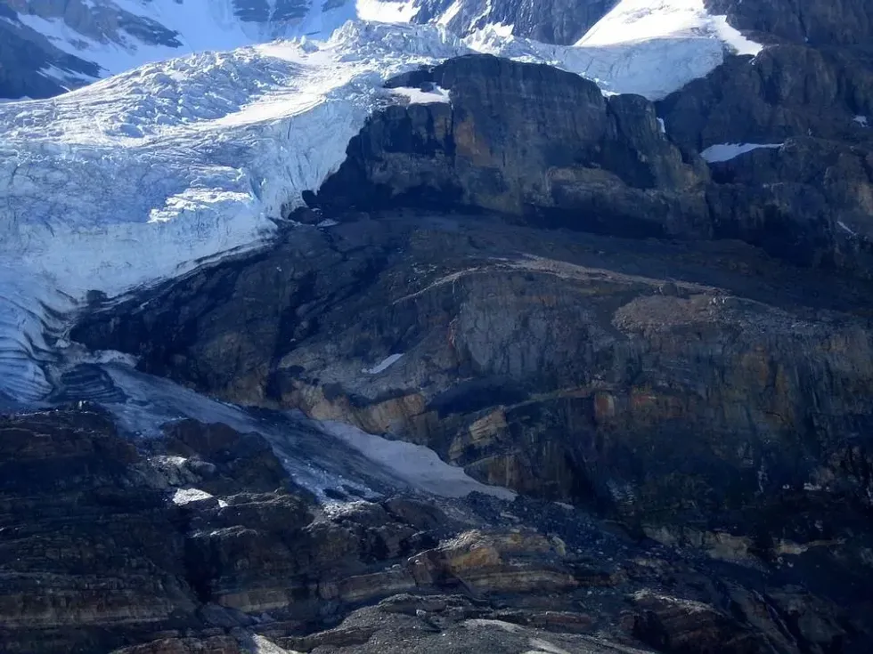
The Athabasca Glacier is located in the Canadian Rockies and is one of the principal 'toes' of the Columbia Icefield, Jasper National Park. It's North America's most-visited glacier, and it's easy to see why.
This massive glacier has a lot to offer to visitors, for its stunning views. This glacier has lost more than half of its total volume over the past 125 years.
Currently, the Athabasca Glacier loses its depth at a rate of 16 ft (5 m) each year, losing 0.93 mi (1.5 km) until now. In this article, we will explore fascinating things you need to know about the Athabasca Glacier!
As climate change continues its devastating effects around the world, we can all take part in ensuring that the glacier stays around as long as possible by making a few small changes. Reduce your reliance on fossil fuels and be more mindful of how much water you use each day.
For example, consider taking public transportation instead of driving or riding a bike when possible; using reusable shopping bags at the grocery store instead of plastic ones; and turning off lights when they aren't needed, such as leaving them on at night or when it can get cold outside during winter months.
Some practical steps can be taken by governments around the world in order to protect glaciers like this one from melting at such alarming rates.
Discovery Of Athabasca Glacier
Athabasca Glacier in the Canadian Rockies located in North America is quite easily accessible, hence making it the most-visited glacier on the continent. The Columbia Icefield, sitting on the Alberta-British Columbia border, is the largest in the Rocky Mountains of North America.
- The Canadian Rockies, where this glacier is located, have many ranges and high peaks.
- The Canadian Rockies are made of limestone and shale. It's a part of the east Canadian Cordillera, of Western Canada.
- The Jasper National Park not only houses Columbia Icefields but also has mountains, waterfalls, lakes, and springs.
- In 1984, the Jasper National Park was recognized as World Heritage Site by UNESCO.
- The Athabasca Glacier was first discovered by European explorers in the 1700s.
- It was named after the Athabasca River, which flows near it.
- The glacier has been continuously studied, making it one of the most well-documented glaciers in the world.
- The glacier was named by David Thompson, a fur trader, and explorer who traveled through the area in the early 1800s.
- Athabasca Glacier can be accessed from three different points; Athabasca Falls, Saskatchewan Crossing, and Sunwapta Falls.
- From the closest parking lot on Icefields Parkway, Alberta, the Athabasca Glacier is within walking distance.
- The Icefields Parkway connects Jasper National Park and Canada's Banff.
- If not properly equipped, traveling on the glacier isn't recommended. Tourists who were not properly equipped have lost their lives due to hidden crevasses.
- The glacier's leading edge is within walking distance and you can easily access the glacier edge.
- Some buses transport tourists to the glacier edge from the center, where you can board snow coaches that take you to the ice, snow, and steep grades up the glacier.
- You can donate to organizations that are trying hard every day in order to resolve some of the issues humankind has caused, such as taking measures to protect this glacier.
- The daily trips of 'Experience the Athabasca Glacier' is open to tourists aged 12 and above. Guests need no previous experience, however, participants must be capable of going on a short hike or climbing a ladder.
- The Athabasca Glacier has been slowly retreating for years. If this trend continues, the glacier could be gone by the end of the century.
- A team from the Canada Science and Technology Museum and Alberta University, in association with Will Gadd, the ice climber, went under this glacier to document and explore the impacts of climate change.
History Of Athabasca Glacier
The Athabasca Glacier has been around for centuries. It's estimated to be at least 12,000 years old. It started forming at the end of the last Ice Age.
- The thickness of Athabasca Glacier lies between 300-980 ft (90-300 m).
- Athabasca Glacier is about 3.7 mi (6 km ) in length with an area of 2.3 sq. mi (6 sq. km).
- The Athabasca Glacier formed as a result of precipitation and ice accumulation.
- Precipitation (rain and snowfall) falls on the surface of slopes of the mountain range and is turned into ice as it passes through the cold air.
- Precipitation turned into ice accumulates over time, forming a glacier.
- The glacier moves because of two main factors; gravity and pressure from the overlying ice.
- Gravity pulls the glacier downhill, while the pressure from the overlying ice helps to push it forward.
- As the glacier moves, it grinds against the rocks on its surface, which causes wear and tear. This process, called abrasion, is responsible for creating many of the interesting features found on glaciers.
- The best way to see the glacier is by driving up Highway 93 (the Icefields Parkway). The parking lot at Wilcox Pass trailhead is where many people go hiking on their own or with guides who can take them on ice-walking tours.
- The most common cause of glacier loss is climate change. You can save this glacier by cutting down on your carbon footprint as much as possible.
- Around the time when it was not a lot warmer than today, some 5,000 years ago, the center of Columbia Icefield was not ice but forest.
- You will find plants filling the forefield, the melt back area when you approach the glacier from the center of Icefield.
- Shrubs are smaller and trees are shorter around the region closer to the ice.
- The location of the terminal moraine of the Athabasca Glacier indicates that around the mid-1840s, the ice front was located where today's Icefield center is.
- The glacier front known as the toe is melting faster than the ice that moves forward.
- Not all winter snow melts in summer at high elevations in the Canadian Rockies.
- Although sunlight at high elevations is strong, the air is a lot cooler due to which a little amount of snow remains at the end of August.

Importance Of Athabasca Glacier
The Athabasca Glacier is important for many reasons, including its contribution to the local water supply and its role in protecting against flooding.
- It also provides a habitat for wildlife such as caribou or elk, which can be found grazing on grasses growing between cracks in snowfields near glacial lakes.
- The Athabasca Glacier has been shrinking for years. Between the years 1890 and 2009, it lost almost 60% of its total surface area.
- The water from snow dome or Columbia icefields flows into the Atlantic, Pacific, and Arctic oceans.
- The water from Columbia Icefields flows west and south into the Pacific Ocean, east into Hudson Bay, eventually into the Atlantic Ocean, and north to the Arctic Ocean.
- During winter that is from mid-October to mid-April, the Columbia Icefield Glacier Discovery Center, sanding across from the Athabasca Glacier is closed.
- The Discovery Center is used to sell sightseeing tickets on the glacier and also as a lodge for tourists.
- Tourists need to book tours and hikes well in advance or depending on the season.
- The guided morning tours and sightseeing can either be enjoyed before 11 a.m. or after 3 a.m. on the Columbia Icefield.
- The glacier can help protect against flooding because it absorbs excess rainwater during periods of high precipitation by storing this liquid at lower elevations where temperatures remain above freezing all year round.
- When there isn't enough snowfall to replenish what's been lost through melting and evaporation over the summer months, meaning that there won't be enough runoff available downstream if no action is taken now.
- The Athabasca Glacier is also an important tourist attraction. It generates millions of dollars for the local economy every year.
- As the glacier continues to shrink, it will become increasingly important to protect and study its unique features.
- Scientists can use information from glaciers like the Athabasca to help them understand how climate change is affecting our planet.
- If the Athabasca Glacier starts melting excessively, it will cause dangerous floods in the surrounding area.
- The staff at the Athabasca Glacier are well-trained, particularly for the glacier tour, which includes background information and educational facts about the glacier.
- A tour for a whole day starts from downtown Jasper, down the Icefields Parkway, and to the glacier, where you will find lunch from a local eatery and crampon.
- A group of a maximum of 10 people is accompanied by a tour guide, who takes the group to places least explored.
- It also provides a habitat for wildlife such as caribou or elk, which can be found grazing on grasses growing between cracks in snowfields near glacial lakes.
Different Types Of Glaciers
There are three main types of glaciers; alpine, continental, and ice shelves. The Athabasca Glacier is a type of continental glacier called an ice field. The structure, shape, and form are called morphology, which varies with topography and climate.
- Mountain glaciers are formed in high mountainous areas, usually covering many peaks or a mountain range and flowing out of icefields. Mountain glaciers also move from a higher region to a lower one, while continental glaciers move outwards in every direction.
- The largest glaciers are located in Asia's Himalayas, South America's Andes, and Alaska's Arctic Canada.
- Valley glaciers spill down from valleys but originate from mountain icefields or glaciers.
- Valley glaciers may be very long, usually flows beyond the snow line, and sometimes reaches sea level.
- Tidewater glaciers are valley glaciers, which flow far enough to join a sea. Tidewater glaciers provide breeding habitats for seals in some places.
- Piedmont glaciers form when steep valley glaciers drop into flat plains spreading out into lobes.
- Alaska's Malaspina Glacier is the world's largest piedmont glacier. It spills out of Seward Icefield.
- Hanging glaciers are formed when the main valley glacier thins and retreats, sometimes leaving tributary glaciers on small valleys on top of the main shrunken glacier surface.
- Rock glaciers are made of rock and ice. These glaciers are identical to normal glaciers in their movements and shapes, but the ice may be restricted to the glacier core or fill spaces in rocks.
- Cirque glaciers are named so because they occupy bowl-like hollows known as cirques.
- Cirque glaciers are rather wide than long and usually occupy high mountainsides.
- The changes in water storage in the land and melting of the Antarctic ice sheet and Greenland ice sheet will increase around half the mass of rising oceans due to climate change.
- Global warming and climate change also cause the expansion of seawater when it warms, increasing almost half of the volume of oceans.
- Ice aprons are small and steep glaciers clinging onto high mountainsides.
- Ice caps are small ice sheets. They typically form in sub-polar and polar areas and are small in comparison to continental ice sheets.
- Icefields are identical to ice caps, but their flow is impacted by topography. Icefields are small in comparison to ice caps.
- Unconstrained glaciers' flow patterns and morphology are mostly independent of the underlying topography.
- A huge ribbon-like glacier standing within an ice sheet is called an ice sheet. Ice borders the ice streams and it flows more slowly.


We Want Your Photos!
More for You


See All
Bachelor of Engineering specializing in Aeronautical/Aerospace Technology, Master of Business Administration specializing in Management
Arpitha RajendraBachelor of Engineering specializing in Aeronautical/Aerospace Technology, Master of Business Administration specializing in Management
With a background in Aeronautical Engineering and practical experience in various technical areas, Arpitha is a valuable member of the Kidadl content writing team. She did her Bachelor's degree in Engineering, specializing in Aeronautical Engineering, at Nitte Meenakshi Institute of Technology in 2020. Arpitha has honed her skills through her work with leading companies in Bangalore, where she contributed to several noteworthy projects, including the development of high-performance aircraft using morphing technology and the analysis of crack propagation using Abaqus XFEM.
Disclaimer
1) Kidadl is independent and to make our service free to you the reader we are supported by advertising. We hope you love our recommendations for products and services! What we suggest is selected independently by the Kidadl team. If you purchase using the Buy Now button we may earn a small commission. This does not influence our choices. Prices are correct and items are available at the time the article was published but we cannot guarantee that on the time of reading. Please note that Kidadl is a participant in the Amazon Services LLC Associates Program, an affiliate advertising program designed to provide a means for sites to earn advertising fees by advertising and linking to Amazon. We also link to other websites, but are not responsible for their content.
2) At Kidadl, we strive to recommend the very best activities and events. We will always aim to give you accurate information at the date of publication - however, information does change, so it’s important you do your own research, double-check and make the decision that is right for your family. We recognise that not all activities and ideas are appropriate for all children and families or in all circumstances. Our recommended activities are based on age but these are a guide. We recommend that these ideas are used as inspiration, that ideas are undertaken with appropriate adult supervision, and that each adult uses their own discretion and knowledge of their children to consider the safety and suitability. Kidadl cannot accept liability for the execution of these ideas, and parental supervision is advised at all times, as safety is paramount. Anyone using the information provided by Kidadl does so at their own risk and we can not accept liability if things go wrong.
3) Because we are an educational resource, we have quotes and facts about a range of historical and modern figures. We do not endorse the actions of or rhetoric of all the people included in these collections, but we think they are important for growing minds to learn about under the guidance of parents or guardians.